L54A Sinclairville, NY, USA - Earthquake Result Viewer
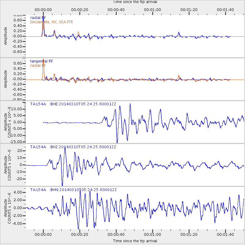
Earthquake location: Off Coast Of Northern California
Earthquake latitude/longitude: 40.8/-125.1
Earthquake time(UTC): 2014/03/10 (069) 05:18:13 GMT
Earthquake Depth: 17 km
Earthquake Magnitude: 6.8 MW, 6.8 MWR, 6.9 MWW, 6.9 MWB, 7.0 MI, 7.0 MWC
Earthquake Catalog/Contributor: NEIC PDE/NEIC COMCAT
Network: TA USArray Transportable Network (new EarthScope stations)
Station: L54A Sinclairville, NY, USA
Lat/Lon: 42.23 N/79.32 W
Elevation: 432 m
Distance: 34.0 deg
Az: 72.19 deg
Baz: 283.385 deg
Ray Param: 0.07792908
Estimated Moho Depth: 49.5 km
Estimated Crust Vp/Vs: 1.74
Assumed Crust Vp: 6.419 km/s
Estimated Crust Vs: 3.684 km/s
Estimated Crust Poisson's Ratio: 0.25
Radial Match: 98.13863 %
Radial Bump: 312
Transverse Match: 93.27505 %
Transverse Bump: 400
SOD ConfigId: 626651
Insert Time: 2014-04-21 03:13:44.976 +0000
GWidth: 2.5
Max Bumps: 400
Tol: 0.001

Signal To Noise

ChannelStoNSTALTA
TA:L54A: :BHZ:20140310T05:24:25.600012Z20.7728373.6128483E-61.7392176E-7
TA:L54A: :BHN:20140310T05:24:25.600012Z2.1586853.9018124E-71.807495E-7
TA:L54A: :BHE:20140310T05:24:25.600012Z11.8270912.0704101E-61.7505657E-7
Arrivals
Ps6.2 SECOND
PpPs20 SECOND
PsPs/PpSs26 SECOND