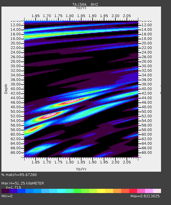
L58A Harry Jones Memorial, Binghamton, NY, USA - Earthquake Result Viewer
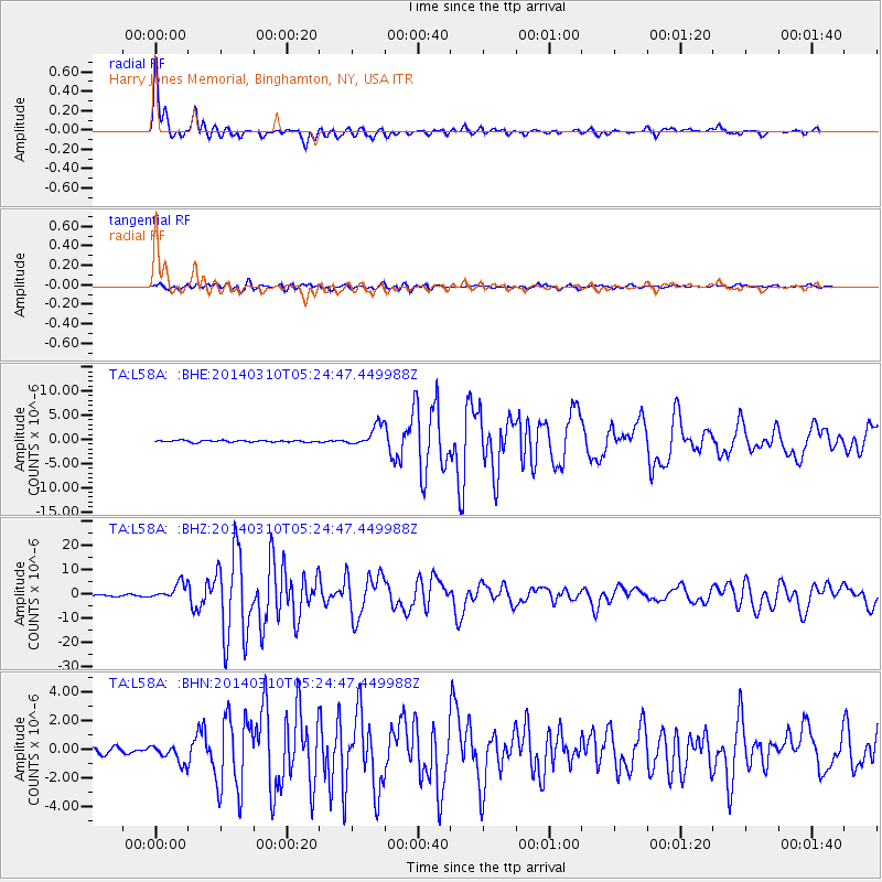
Earthquake location: Off Coast Of Northern California
Earthquake latitude/longitude: 40.8/-125.1
Earthquake time(UTC): 2014/03/10 (069) 05:18:13 GMT
Earthquake Depth: 17 km
Earthquake Magnitude: 6.8 MW, 6.8 MWR, 6.9 MWW, 6.9 MWB, 7.0 MI, 7.0 MWC
Earthquake Catalog/Contributor: NEIC PDE/NEIC COMCAT
Network: TA USArray Transportable Network (new EarthScope stations)
Station: L58A Harry Jones Memorial, Binghamton, NY, USA
Lat/Lon: 42.04 N/75.85 W
Elevation: 447 m
Distance: 36.6 deg
Az: 71.412 deg
Baz: 285.067 deg
Ray Param: 0.076599255
Estimated Moho Depth: 51.25 km
Estimated Crust Vp/Vs: 1.72
Assumed Crust Vp: 6.419 km/s
Estimated Crust Vs: 3.743 km/s
Estimated Crust Poisson's Ratio: 0.24
Radial Match: 95.67268 %
Radial Bump: 400
Transverse Match: 87.82684 %
Transverse Bump: 400
SOD ConfigId: 626651
Insert Time: 2014-04-21 03:13:55.258 +0000
GWidth: 2.5
Max Bumps: 400
Tol: 0.001

Signal To Noise

ChannelStoNSTALTA
TA:L58A: :BHZ:20140310T05:24:47.449988Z11.3584993.3748709E-62.97123E-7
TA:L58A: :BHN:20140310T05:24:47.449988Z2.90616.2282334E-72.1431586E-7
TA:L58A: :BHE:20140310T05:24:47.449988Z11.7455382.1618498E-61.840571E-7
Arrivals
Ps6.2 SECOND
PpPs20 SECOND
PsPs/PpSs26 SECOND