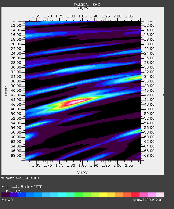
L59A Walton, NY, USA - Earthquake Result Viewer

Earthquake location: Off Coast Of Northern California
Earthquake latitude/longitude: 40.8/-125.1
Earthquake time(UTC): 2014/03/10 (069) 05:18:13 GMT
Earthquake Depth: 17 km
Earthquake Magnitude: 6.8 MW, 6.8 MWR, 6.9 MWW, 6.9 MWB, 7.0 MI, 7.0 MWC
Earthquake Catalog/Contributor: NEIC PDE/NEIC COMCAT
Network: TA USArray Transportable Network (new EarthScope stations)
Station: L59A Walton, NY, USA
Lat/Lon: 42.19 N/75.04 W
Elevation: 677 m
Distance: 37.1 deg
Az: 70.916 deg
Baz: 285.21 deg
Ray Param: 0.076304056
Estimated Moho Depth: 44.5 km
Estimated Crust Vp/Vs: 1.83
Assumed Crust Vp: 6.419 km/s
Estimated Crust Vs: 3.517 km/s
Estimated Crust Poisson's Ratio: 0.29
Radial Match: 95.434364 %
Radial Bump: 381
Transverse Match: 89.51091 %
Transverse Bump: 400
SOD ConfigId: 626651
Insert Time: 2014-04-21 03:13:57.721 +0000
GWidth: 2.5
Max Bumps: 400
Tol: 0.001

Signal To Noise

ChannelStoNSTALTA
TA:L59A: :BHZ:20140310T05:24:52.049994Z12.5850283.076514E-62.4445825E-7
TA:L59A: :BHN:20140310T05:24:52.049994Z3.49510056.442036E-71.8431619E-7
TA:L59A: :BHE:20140310T05:24:52.049994Z6.9274941.8132844E-62.6175186E-7
Arrivals
Ps6.1 SECOND
PpPs18 SECOND
PsPs/PpSs24 SECOND