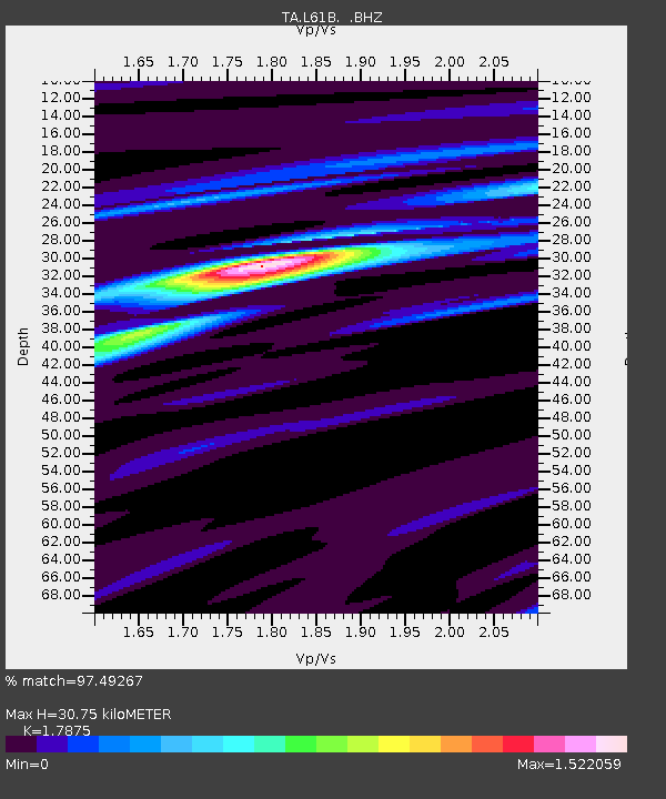
L61B Northampton, MA, USA - Earthquake Result Viewer

Earthquake location: Off Coast Of Northern California
Earthquake latitude/longitude: 40.8/-125.1
Earthquake time(UTC): 2014/03/10 (069) 05:18:13 GMT
Earthquake Depth: 17 km
Earthquake Magnitude: 6.8 MW, 6.8 MWR, 6.9 MWW, 6.9 MWB, 7.0 MI, 7.0 MWC
Earthquake Catalog/Contributor: NEIC PDE/NEIC COMCAT
Network: TA USArray Transportable Network (new EarthScope stations)
Station: L61B Northampton, MA, USA
Lat/Lon: 42.45 N/72.68 W
Elevation: 261 m
Distance: 38.7 deg
Az: 69.745 deg
Baz: 285.871 deg
Ray Param: 0.07538317
Estimated Moho Depth: 30.75 km
Estimated Crust Vp/Vs: 1.79
Assumed Crust Vp: 6.419 km/s
Estimated Crust Vs: 3.591 km/s
Estimated Crust Poisson's Ratio: 0.27
Radial Match: 97.49267 %
Radial Bump: 284
Transverse Match: 91.345924 %
Transverse Bump: 400
SOD ConfigId: 626651
Insert Time: 2014-04-21 03:14:02.614 +0000
GWidth: 2.5
Max Bumps: 400
Tol: 0.001

Signal To Noise

ChannelStoNSTALTA
TA:L61B: :BHZ:20140310T05:25:05.699988Z7.9688132.3314617E-62.9257328E-7
TA:L61B: :BHN:20140310T05:25:05.699988Z2.26411913.679142E-71.6249771E-7
TA:L61B: :BHE:20140310T05:25:05.699988Z6.2135371.2406282E-61.9966537E-7
Arrivals
Ps4.1 SECOND
PpPs12 SECOND
PsPs/PpSs16 SECOND