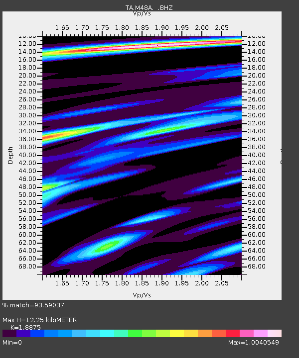
M48A Edgerton, OH, USA - Earthquake Result Viewer
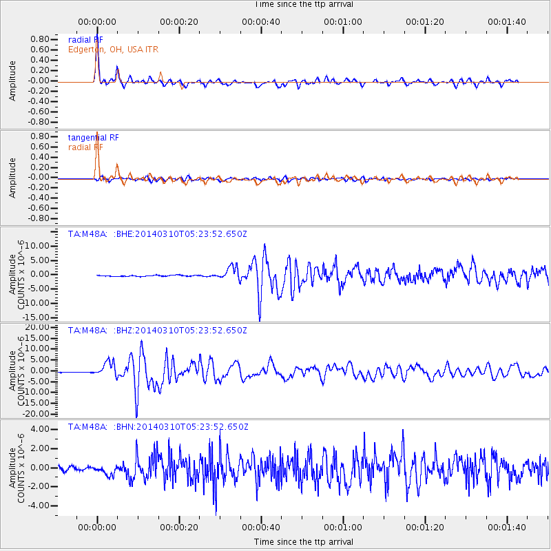
Earthquake location: Off Coast Of Northern California
Earthquake latitude/longitude: 40.8/-125.1
Earthquake time(UTC): 2014/03/10 (069) 05:18:13 GMT
Earthquake Depth: 17 km
Earthquake Magnitude: 6.8 MW, 6.8 MWR, 6.9 MWW, 6.9 MWB, 7.0 MI, 7.0 MWC
Earthquake Catalog/Contributor: NEIC PDE/NEIC COMCAT
Network: TA USArray Transportable Network (new EarthScope stations)
Station: M48A Edgerton, OH, USA
Lat/Lon: 41.48 N/84.72 W
Elevation: 258 m
Distance: 30.2 deg
Az: 75.254 deg
Baz: 282.389 deg
Ray Param: 0.07937437
Estimated Moho Depth: 12.25 km
Estimated Crust Vp/Vs: 1.89
Assumed Crust Vp: 6.498 km/s
Estimated Crust Vs: 3.442 km/s
Estimated Crust Poisson's Ratio: 0.30
Radial Match: 93.59037 %
Radial Bump: 344
Transverse Match: 77.156654 %
Transverse Bump: 400
SOD ConfigId: 626651
Insert Time: 2014-04-21 03:14:13.825 +0000
GWidth: 2.5
Max Bumps: 400
Tol: 0.001

Signal To Noise

ChannelStoNSTALTA
TA:M48A: :BHZ:20140310T05:23:52.650Z28.5146623.4644338E-61.2149657E-7
TA:M48A: :BHN:20140310T05:23:52.650Z3.1202365.538556E-71.775044E-7
TA:M48A: :BHE:20140310T05:23:52.650Z12.7721642.3496443E-61.8396604E-7
Arrivals
Ps1.8 SECOND
PpPs5.0 SECOND
PsPs/PpSs6.8 SECOND