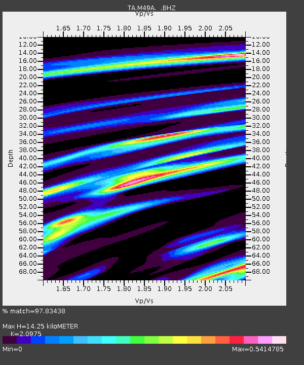
M49A Liberty Center, OH, USA - Earthquake Result Viewer
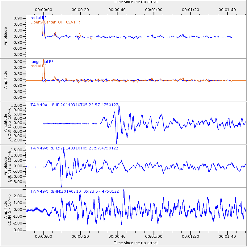
Earthquake location: Off Coast Of Northern California
Earthquake latitude/longitude: 40.8/-125.1
Earthquake time(UTC): 2014/03/10 (069) 05:18:13 GMT
Earthquake Depth: 17 km
Earthquake Magnitude: 6.8 MW, 6.8 MWR, 6.9 MWW, 6.9 MWB, 7.0 MI, 7.0 MWC
Earthquake Catalog/Contributor: NEIC PDE/NEIC COMCAT
Network: TA USArray Transportable Network (new EarthScope stations)
Station: M49A Liberty Center, OH, USA
Lat/Lon: 41.47 N/83.98 W
Elevation: 203 m
Distance: 30.8 deg
Az: 75.035 deg
Baz: 282.69 deg
Ray Param: 0.07923085
Estimated Moho Depth: 14.25 km
Estimated Crust Vp/Vs: 2.10
Assumed Crust Vp: 6.498 km/s
Estimated Crust Vs: 3.098 km/s
Estimated Crust Poisson's Ratio: 0.35
Radial Match: 97.83438 %
Radial Bump: 225
Transverse Match: 88.194305 %
Transverse Bump: 400
SOD ConfigId: 626651
Insert Time: 2014-04-21 03:14:15.090 +0000
GWidth: 2.5
Max Bumps: 400
Tol: 0.001

Signal To Noise

ChannelStoNSTALTA
TA:M49A: :BHZ:20140310T05:23:57.475012Z25.2482973.217426E-61.274314E-7
TA:M49A: :BHN:20140310T05:23:57.475012Z3.21544273.860664E-71.2006633E-7
TA:M49A: :BHE:20140310T05:23:57.475012Z18.8772932.2498975E-61.19185394E-7
Arrivals
Ps2.6 SECOND
PpPs6.3 SECOND
PsPs/PpSs8.9 SECOND