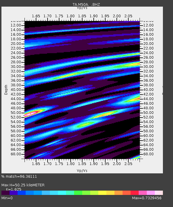
M50A Fremont, OH, USA - Earthquake Result Viewer
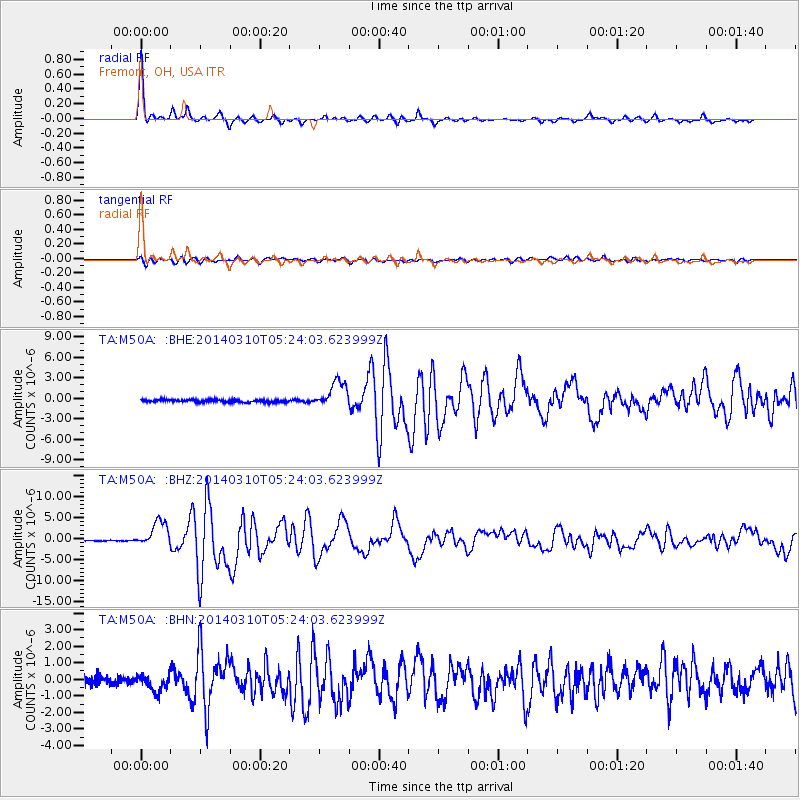
Earthquake location: Off Coast Of Northern California
Earthquake latitude/longitude: 40.8/-125.1
Earthquake time(UTC): 2014/03/10 (069) 05:18:13 GMT
Earthquake Depth: 17 km
Earthquake Magnitude: 6.8 MW, 6.8 MWR, 6.9 MWW, 6.9 MWB, 7.0 MI, 7.0 MWC
Earthquake Catalog/Contributor: NEIC PDE/NEIC COMCAT
Network: TA USArray Transportable Network (new EarthScope stations)
Station: M50A Fremont, OH, USA
Lat/Lon: 41.40 N/83.04 W
Elevation: 176 m
Distance: 31.5 deg
Az: 74.865 deg
Baz: 283.16 deg
Ray Param: 0.079041146
Estimated Moho Depth: 50.25 km
Estimated Crust Vp/Vs: 1.62
Assumed Crust Vp: 6.498 km/s
Estimated Crust Vs: 3.998 km/s
Estimated Crust Poisson's Ratio: 0.20
Radial Match: 96.36111 %
Radial Bump: 265
Transverse Match: 87.151215 %
Transverse Bump: 400
SOD ConfigId: 626651
Insert Time: 2014-04-21 03:14:18.171 +0000
GWidth: 2.5
Max Bumps: 400
Tol: 0.001

Signal To Noise

ChannelStoNSTALTA
TA:M50A: :BHZ:20140310T05:24:03.623999Z14.7575812.9848397E-62.0225806E-7
TA:M50A: :BHN:20140310T05:24:03.623999Z1.72905535.024389E-72.905858E-7
TA:M50A: :BHE:20140310T05:24:03.623999Z10.3528381.940779E-61.8746348E-7
Arrivals
Ps5.3 SECOND
PpPs19 SECOND
PsPs/PpSs24 SECOND