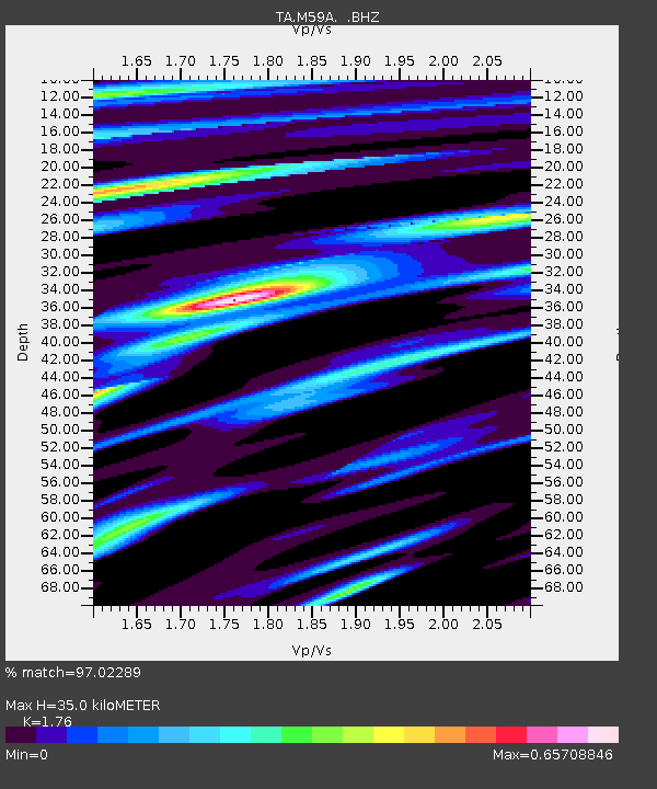
M59A Waymart, PA, USA - Earthquake Result Viewer
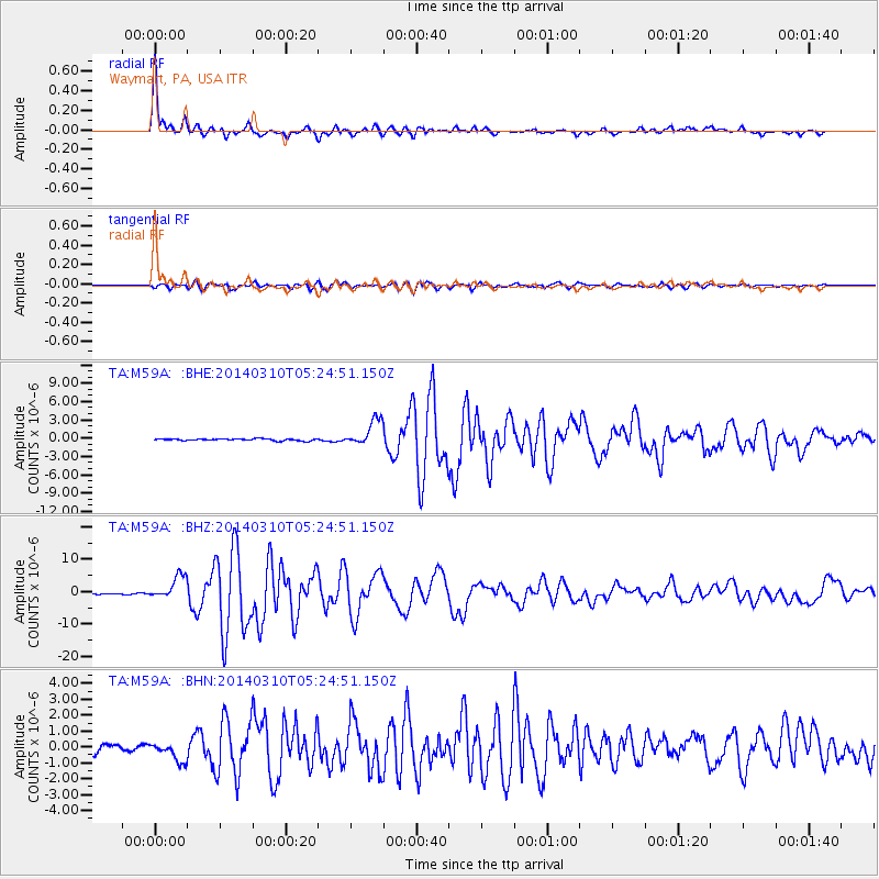
Earthquake location: Off Coast Of Northern California
Earthquake latitude/longitude: 40.8/-125.1
Earthquake time(UTC): 2014/03/10 (069) 05:18:13 GMT
Earthquake Depth: 17 km
Earthquake Magnitude: 6.8 MW, 6.8 MWR, 6.9 MWW, 6.9 MWB, 7.0 MI, 7.0 MWC
Earthquake Catalog/Contributor: NEIC PDE/NEIC COMCAT
Network: TA USArray Transportable Network (new EarthScope stations)
Station: M59A Waymart, PA, USA
Lat/Lon: 41.54 N/75.43 W
Elevation: 471 m
Distance: 37.0 deg
Az: 72.082 deg
Baz: 285.882 deg
Ray Param: 0.076362066
Estimated Moho Depth: 35.0 km
Estimated Crust Vp/Vs: 1.76
Assumed Crust Vp: 6.283 km/s
Estimated Crust Vs: 3.57 km/s
Estimated Crust Poisson's Ratio: 0.26
Radial Match: 97.02289 %
Radial Bump: 346
Transverse Match: 90.960144 %
Transverse Bump: 400
SOD ConfigId: 626651
Insert Time: 2014-04-21 03:14:38.656 +0000
GWidth: 2.5
Max Bumps: 400
Tol: 0.001

Signal To Noise

ChannelStoNSTALTA
TA:M59A: :BHZ:20140310T05:24:51.150Z24.567453.622753E-61.474615E-7
TA:M59A: :BHN:20140310T05:24:51.150Z2.59864836.175963E-72.3766061E-7
TA:M59A: :BHE:20140310T05:24:51.150Z13.8828842.1216692E-61.5282626E-7
Arrivals
Ps4.5 SECOND
PpPs14 SECOND
PsPs/PpSs19 SECOND