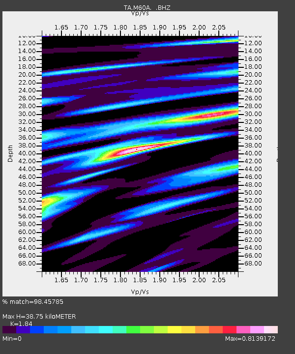
M60A Port Jervis, NY, USA - Earthquake Result Viewer

Earthquake location: Off Coast Of Northern California
Earthquake latitude/longitude: 40.8/-125.1
Earthquake time(UTC): 2014/03/10 (069) 05:18:13 GMT
Earthquake Depth: 17 km
Earthquake Magnitude: 6.8 MW, 6.8 MWR, 6.9 MWW, 6.9 MWB, 7.0 MI, 7.0 MWC
Earthquake Catalog/Contributor: NEIC PDE/NEIC COMCAT
Network: TA USArray Transportable Network (new EarthScope stations)
Station: M60A Port Jervis, NY, USA
Lat/Lon: 41.33 N/74.62 W
Elevation: 292 m
Distance: 37.6 deg
Az: 72.143 deg
Baz: 286.462 deg
Ray Param: 0.076009616
Estimated Moho Depth: 38.75 km
Estimated Crust Vp/Vs: 1.84
Assumed Crust Vp: 6.283 km/s
Estimated Crust Vs: 3.415 km/s
Estimated Crust Poisson's Ratio: 0.29
Radial Match: 98.45785 %
Radial Bump: 329
Transverse Match: 93.67231 %
Transverse Bump: 400
SOD ConfigId: 626651
Insert Time: 2014-04-21 03:14:40.118 +0000
GWidth: 2.5
Max Bumps: 400
Tol: 0.001

Signal To Noise

ChannelStoNSTALTA
TA:M60A: :BHZ:20140310T05:24:56.599005Z18.3986913.410932E-61.8538994E-7
TA:M60A: :BHN:20140310T05:24:56.599005Z3.21726686.7299635E-72.0918263E-7
TA:M60A: :BHE:20140310T05:24:56.599005Z13.9443772.2580932E-61.6193574E-7
Arrivals
Ps5.5 SECOND
PpPs16 SECOND
PsPs/PpSs22 SECOND