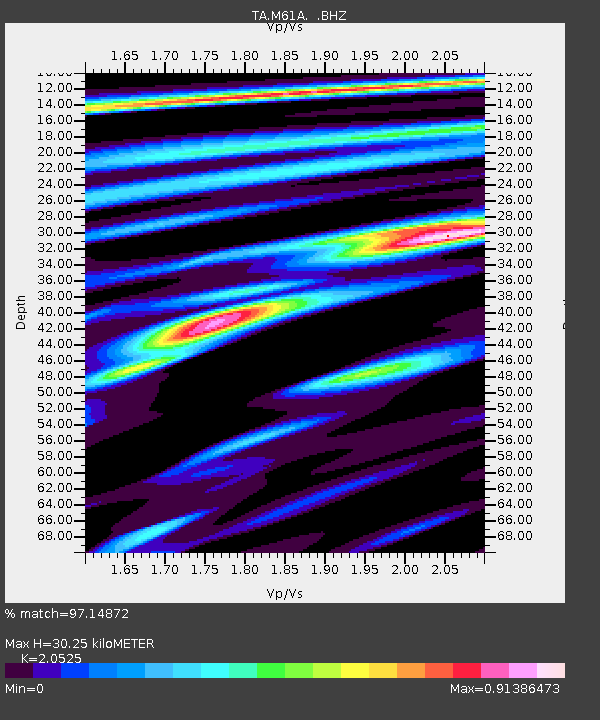
M61A Granite Springs, NY, USA - Earthquake Result Viewer

Earthquake location: Off Coast Of Northern California
Earthquake latitude/longitude: 40.8/-125.1
Earthquake time(UTC): 2014/03/10 (069) 05:18:13 GMT
Earthquake Depth: 17 km
Earthquake Magnitude: 6.8 MW, 6.8 MWR, 6.9 MWW, 6.9 MWB, 7.0 MI, 7.0 MWC
Earthquake Catalog/Contributor: NEIC PDE/NEIC COMCAT
Network: TA USArray Transportable Network (new EarthScope stations)
Station: M61A Granite Springs, NY, USA
Lat/Lon: 41.31 N/73.77 W
Elevation: 190 m
Distance: 38.3 deg
Az: 71.867 deg
Baz: 286.809 deg
Ray Param: 0.07564811
Estimated Moho Depth: 30.25 km
Estimated Crust Vp/Vs: 2.05
Assumed Crust Vp: 6.472 km/s
Estimated Crust Vs: 3.153 km/s
Estimated Crust Poisson's Ratio: 0.34
Radial Match: 97.14872 %
Radial Bump: 285
Transverse Match: 87.32313 %
Transverse Bump: 400
SOD ConfigId: 626651
Insert Time: 2014-04-21 03:14:42.773 +0000
GWidth: 2.5
Max Bumps: 400
Tol: 0.001

Signal To Noise

ChannelStoNSTALTA
TA:M61A: :BHZ:20140310T05:25:01.849005Z9.9912633.19315E-63.1959422E-7
TA:M61A: :BHN:20140310T05:25:01.849005Z2.67937066.644682E-72.4799414E-7
TA:M61A: :BHE:20140310T05:25:01.849005Z8.5506911.8983237E-62.2200823E-7
Arrivals
Ps5.2 SECOND
PpPs13 SECOND
PsPs/PpSs19 SECOND