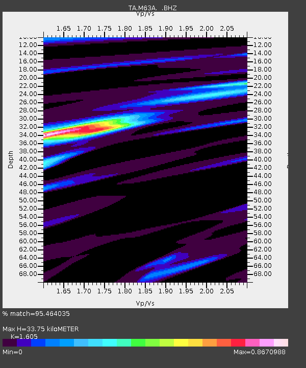
M63A Gales Ferry, CT, USA - Earthquake Result Viewer

Earthquake location: Off Coast Of Northern California
Earthquake latitude/longitude: 40.8/-125.1
Earthquake time(UTC): 2014/03/10 (069) 05:18:13 GMT
Earthquake Depth: 17 km
Earthquake Magnitude: 6.8 MW, 6.8 MWR, 6.9 MWW, 6.9 MWB, 7.0 MI, 7.0 MWC
Earthquake Catalog/Contributor: NEIC PDE/NEIC COMCAT
Network: TA USArray Transportable Network (new EarthScope stations)
Station: M63A Gales Ferry, CT, USA
Lat/Lon: 41.40 N/72.05 W
Elevation: 44 m
Distance: 39.5 deg
Az: 71.119 deg
Baz: 287.359 deg
Ray Param: 0.07494885
Estimated Moho Depth: 33.75 km
Estimated Crust Vp/Vs: 1.61
Assumed Crust Vp: 6.472 km/s
Estimated Crust Vs: 4.032 km/s
Estimated Crust Poisson's Ratio: 0.18
Radial Match: 95.464035 %
Radial Bump: 257
Transverse Match: 77.66656 %
Transverse Bump: 400
SOD ConfigId: 626651
Insert Time: 2014-04-21 03:14:47.122 +0000
GWidth: 2.5
Max Bumps: 400
Tol: 0.001

Signal To Noise

ChannelStoNSTALTA
TA:M63A: :BHZ:20140310T05:25:11.998999Z10.6558022.6742318E-62.5096486E-7
TA:M63A: :BHN:20140310T05:25:11.998999Z1.64554495.194224E-73.1565372E-7
TA:M63A: :BHE:20140310T05:25:11.998999Z6.28106741.8117147E-62.884406E-7
Arrivals
Ps3.4 SECOND
PpPs13 SECOND
PsPs/PpSs16 SECOND