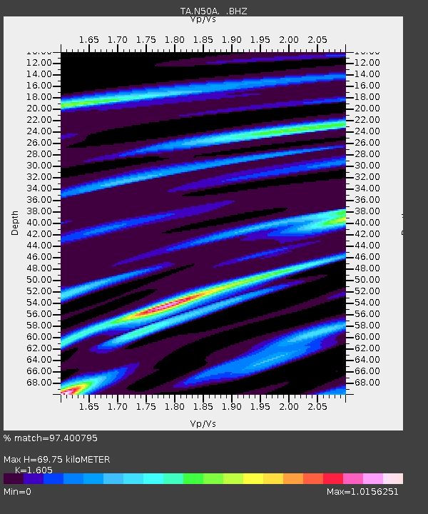
N50A Nevada, OH, USA - Earthquake Result Viewer
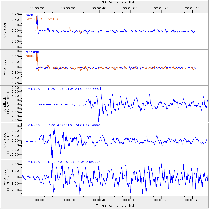
Earthquake location: Off Coast Of Northern California
Earthquake latitude/longitude: 40.8/-125.1
Earthquake time(UTC): 2014/03/10 (069) 05:18:13 GMT
Earthquake Depth: 17 km
Earthquake Magnitude: 6.8 MW, 6.8 MWR, 6.9 MWW, 6.9 MWB, 7.0 MI, 7.0 MWC
Earthquake Catalog/Contributor: NEIC PDE/NEIC COMCAT
Network: TA USArray Transportable Network (new EarthScope stations)
Station: N50A Nevada, OH, USA
Lat/Lon: 40.77 N/83.15 W
Elevation: 277 m
Distance: 31.6 deg
Az: 76.075 deg
Baz: 284.122 deg
Ray Param: 0.07901083
Estimated Moho Depth: 69.75 km
Estimated Crust Vp/Vs: 1.61
Assumed Crust Vp: 6.498 km/s
Estimated Crust Vs: 4.048 km/s
Estimated Crust Poisson's Ratio: 0.18
Radial Match: 97.400795 %
Radial Bump: 305
Transverse Match: 86.43277 %
Transverse Bump: 400
SOD ConfigId: 626651
Insert Time: 2014-04-21 03:14:59.759 +0000
GWidth: 2.5
Max Bumps: 400
Tol: 0.001

Signal To Noise

ChannelStoNSTALTA
TA:N50A: :BHZ:20140310T05:24:04.248999Z15.3753363.125903E-62.0330633E-7
TA:N50A: :BHN:20140310T05:24:04.248999Z2.8827424.6187643E-71.6022122E-7
TA:N50A: :BHE:20140310T05:24:04.248999Z8.80062.014156E-62.2886577E-7
Arrivals
Ps7.1 SECOND
PpPs26 SECOND
PsPs/PpSs33 SECOND