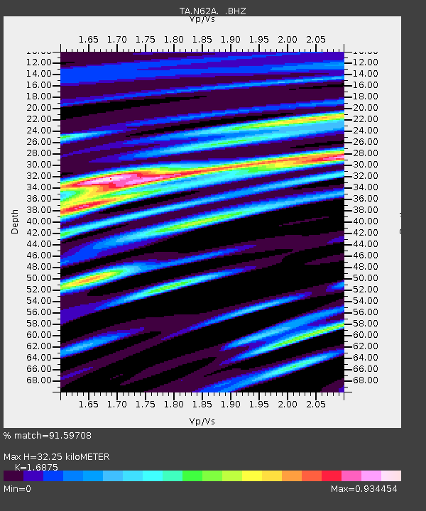
N62A Caumsett State Park, Huntington, NY, USA - Earthquake Result Viewer

Earthquake location: Off Coast Of Northern California
Earthquake latitude/longitude: 40.8/-125.1
Earthquake time(UTC): 2014/03/10 (069) 05:18:13 GMT
Earthquake Depth: 17 km
Earthquake Magnitude: 6.8 MW, 6.8 MWR, 6.9 MWW, 6.9 MWB, 7.0 MI, 7.0 MWC
Earthquake Catalog/Contributor: NEIC PDE/NEIC COMCAT
Network: TA USArray Transportable Network (new EarthScope stations)
Station: N62A Caumsett State Park, Huntington, NY, USA
Lat/Lon: 40.93 N/73.47 W
Elevation: 34 m
Distance: 38.6 deg
Az: 72.343 deg
Baz: 287.378 deg
Ray Param: 0.075458884
Estimated Moho Depth: 32.25 km
Estimated Crust Vp/Vs: 1.69
Assumed Crust Vp: 6.472 km/s
Estimated Crust Vs: 3.835 km/s
Estimated Crust Poisson's Ratio: 0.23
Radial Match: 91.59708 %
Radial Bump: 400
Transverse Match: 83.24313 %
Transverse Bump: 400
SOD ConfigId: 626651
Insert Time: 2014-04-21 03:15:26.770 +0000
GWidth: 2.5
Max Bumps: 400
Tol: 0.001

Signal To Noise

ChannelStoNSTALTA
TA:N62A: :BHZ:20140310T05:25:04.600012Z13.1935432.9183961E-62.211988E-7
TA:N62A: :BHN:20140310T05:25:04.600012Z2.77506976.699552E-72.4141926E-7
TA:N62A: :BHE:20140310T05:25:04.600012Z6.3919931.802268E-62.8195714E-7
Arrivals
Ps3.7 SECOND
PpPs12 SECOND
PsPs/PpSs16 SECOND