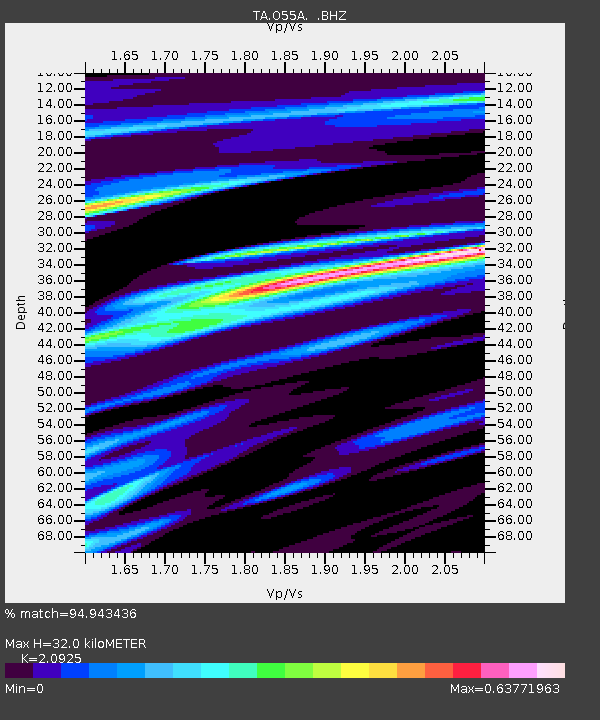
O55A Ligonier, PA, USA - Earthquake Result Viewer
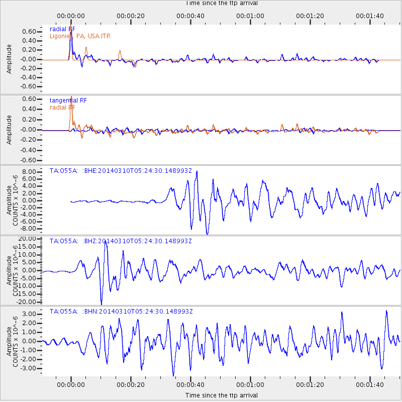
Earthquake location: Off Coast Of Northern California
Earthquake latitude/longitude: 40.8/-125.1
Earthquake time(UTC): 2014/03/10 (069) 05:18:13 GMT
Earthquake Depth: 17 km
Earthquake Magnitude: 6.8 MW, 6.8 MWR, 6.9 MWW, 6.9 MWB, 7.0 MI, 7.0 MWC
Earthquake Catalog/Contributor: NEIC PDE/NEIC COMCAT
Network: TA USArray Transportable Network (new EarthScope stations)
Station: O55A Ligonier, PA, USA
Lat/Lon: 40.21 N/79.30 W
Elevation: 469 m
Distance: 34.5 deg
Az: 75.662 deg
Baz: 286.263 deg
Ray Param: 0.07767353
Estimated Moho Depth: 32.0 km
Estimated Crust Vp/Vs: 2.09
Assumed Crust Vp: 6.121 km/s
Estimated Crust Vs: 2.925 km/s
Estimated Crust Poisson's Ratio: 0.35
Radial Match: 94.943436 %
Radial Bump: 400
Transverse Match: 82.42319 %
Transverse Bump: 400
SOD ConfigId: 626651
Insert Time: 2014-04-21 03:15:48.986 +0000
GWidth: 2.5
Max Bumps: 400
Tol: 0.001

Signal To Noise

ChannelStoNSTALTA
TA:O55A: :BHZ:20140310T05:24:30.148993Z12.4897553.3820143E-62.707831E-7
TA:O55A: :BHN:20140310T05:24:30.148993Z2.89295346.810477E-72.3541607E-7
TA:O55A: :BHE:20140310T05:24:30.148993Z13.5312172.0063696E-61.4827711E-7
Arrivals
Ps6.1 SECOND
PpPs15 SECOND
PsPs/PpSs21 SECOND