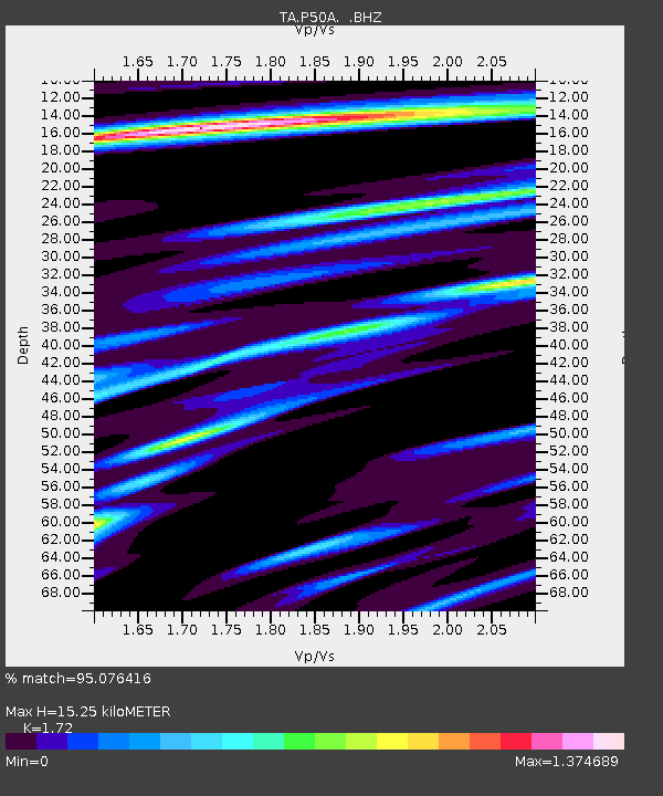
P50A Jamestown, OH, USA - Earthquake Result Viewer

Earthquake location: Off Coast Of Northern California
Earthquake latitude/longitude: 40.8/-125.1
Earthquake time(UTC): 2014/03/10 (069) 05:18:13 GMT
Earthquake Depth: 17 km
Earthquake Magnitude: 6.8 MW, 6.8 MWR, 6.9 MWW, 6.9 MWB, 7.0 MI, 7.0 MWC
Earthquake Catalog/Contributor: NEIC PDE/NEIC COMCAT
Network: TA USArray Transportable Network (new EarthScope stations)
Station: P50A Jamestown, OH, USA
Lat/Lon: 39.61 N/83.80 W
Elevation: 318 m
Distance: 31.4 deg
Az: 78.47 deg
Baz: 285.747 deg
Ray Param: 0.0790763
Estimated Moho Depth: 15.25 km
Estimated Crust Vp/Vs: 1.72
Assumed Crust Vp: 6.232 km/s
Estimated Crust Vs: 3.623 km/s
Estimated Crust Poisson's Ratio: 0.24
Radial Match: 95.076416 %
Radial Bump: 386
Transverse Match: 83.39528 %
Transverse Bump: 400
SOD ConfigId: 626651
Insert Time: 2014-04-21 03:16:08.803 +0000
GWidth: 2.5
Max Bumps: 400
Tol: 0.001

Signal To Noise

ChannelStoNSTALTA
TA:P50A: :BHZ:20140310T05:24:02.650Z15.8222633.114913E-61.96869E-7
TA:P50A: :BHN:20140310T05:24:02.650Z5.0656146.826833E-71.3476813E-7
TA:P50A: :BHE:20140310T05:24:02.650Z16.5425242.0876382E-61.2619829E-7
Arrivals
Ps1.9 SECOND
PpPs6.2 SECOND
PsPs/PpSs8.1 SECOND