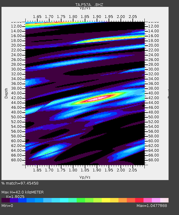
P57A Homestead Farm, Martinsburg, WV, USA - Earthquake Result Viewer
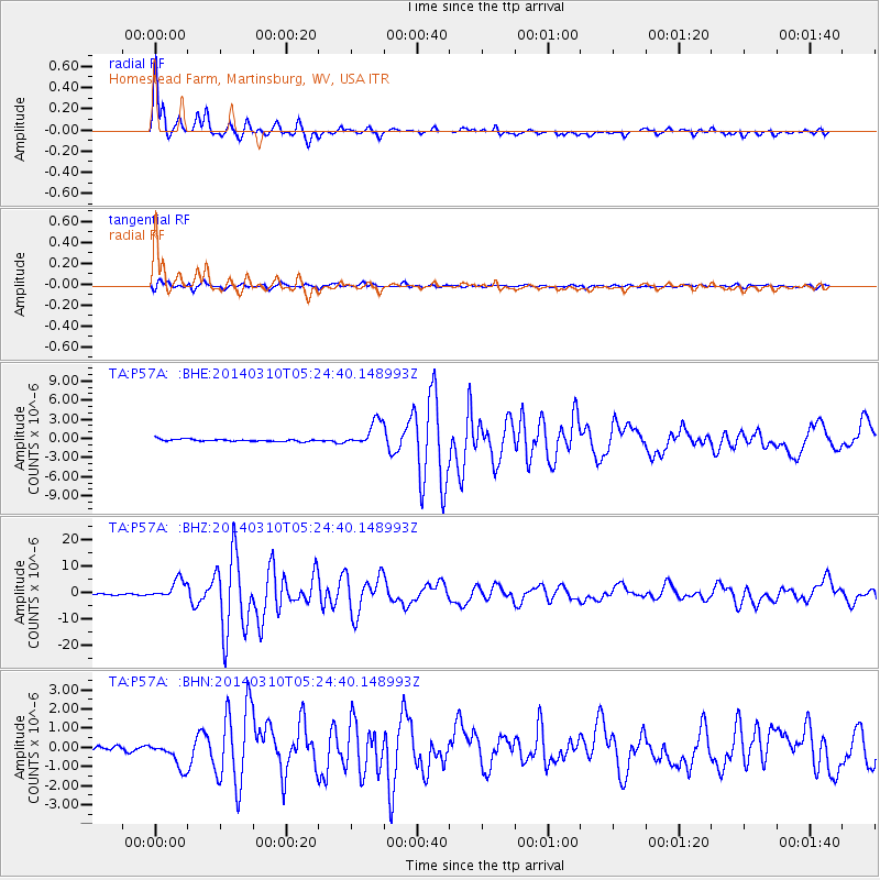
Earthquake location: Off Coast Of Northern California
Earthquake latitude/longitude: 40.8/-125.1
Earthquake time(UTC): 2014/03/10 (069) 05:18:13 GMT
Earthquake Depth: 17 km
Earthquake Magnitude: 6.8 MW, 6.8 MWR, 6.9 MWW, 6.9 MWB, 7.0 MI, 7.0 MWC
Earthquake Catalog/Contributor: NEIC PDE/NEIC COMCAT
Network: TA USArray Transportable Network (new EarthScope stations)
Station: P57A Homestead Farm, Martinsburg, WV, USA
Lat/Lon: 39.48 N/78.01 W
Elevation: 191 m
Distance: 35.7 deg
Az: 76.36 deg
Baz: 287.658 deg
Ray Param: 0.07706523
Estimated Moho Depth: 42.0 km
Estimated Crust Vp/Vs: 1.90
Assumed Crust Vp: 6.159 km/s
Estimated Crust Vs: 3.237 km/s
Estimated Crust Poisson's Ratio: 0.31
Radial Match: 97.45458 %
Radial Bump: 356
Transverse Match: 87.77788 %
Transverse Bump: 400
SOD ConfigId: 626651
Insert Time: 2014-04-21 03:16:27.610 +0000
GWidth: 2.5
Max Bumps: 400
Tol: 0.001

Signal To Noise

ChannelStoNSTALTA
TA:P57A: :BHZ:20140310T05:24:40.148993Z17.8587973.5785486E-62.0038016E-7
TA:P57A: :BHN:20140310T05:24:40.148993Z5.58499967.1385466E-71.2781642E-7
TA:P57A: :BHE:20140310T05:24:40.148993Z11.4372141.9526237E-61.7072547E-7
Arrivals
Ps6.6 SECOND
PpPs19 SECOND
PsPs/PpSs25 SECOND