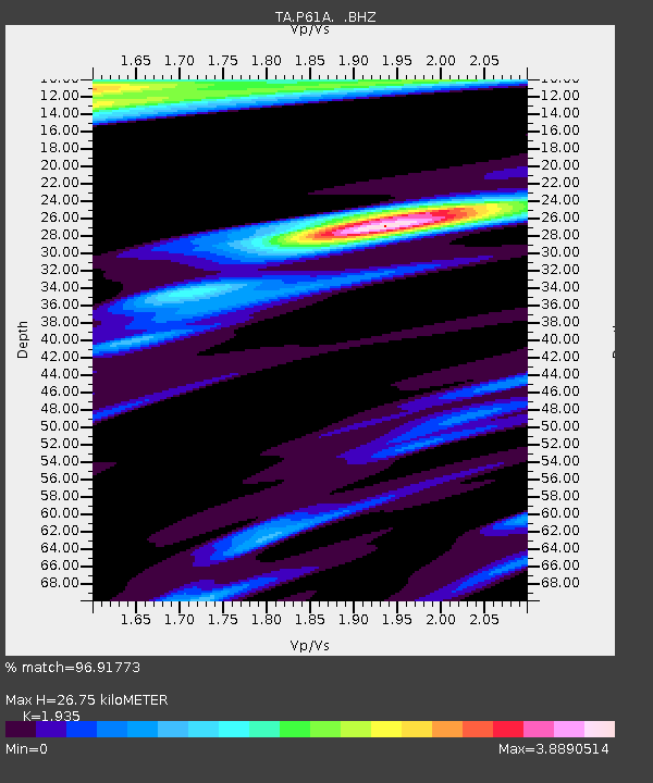
P61A Hammonton, NJ, USA - Earthquake Result Viewer
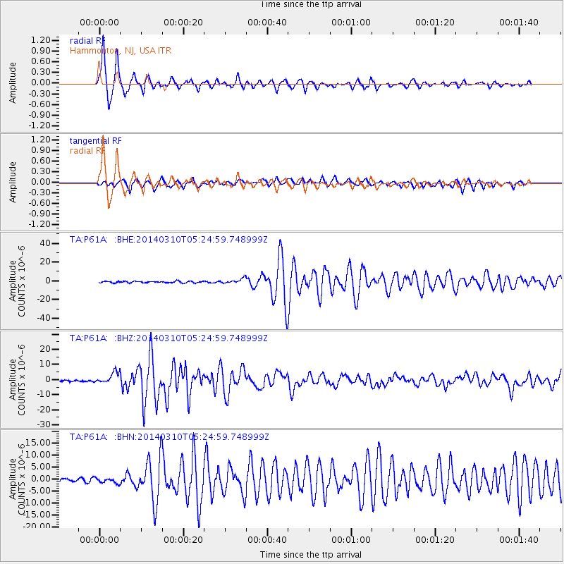
Earthquake location: Off Coast Of Northern California
Earthquake latitude/longitude: 40.8/-125.1
Earthquake time(UTC): 2014/03/10 (069) 05:18:13 GMT
Earthquake Depth: 17 km
Earthquake Magnitude: 6.8 MW, 6.8 MWR, 6.9 MWW, 6.9 MWB, 7.0 MI, 7.0 MWC
Earthquake Catalog/Contributor: NEIC PDE/NEIC COMCAT
Network: TA USArray Transportable Network (new EarthScope stations)
Station: P61A Hammonton, NJ, USA
Lat/Lon: 39.67 N/74.79 W
Elevation: 22 m
Distance: 38.0 deg
Az: 74.774 deg
Baz: 288.433 deg
Ray Param: 0.07579243
Estimated Moho Depth: 26.75 km
Estimated Crust Vp/Vs: 1.93
Assumed Crust Vp: 6.287 km/s
Estimated Crust Vs: 3.249 km/s
Estimated Crust Poisson's Ratio: 0.32
Radial Match: 96.91773 %
Radial Bump: 338
Transverse Match: 90.4802 %
Transverse Bump: 400
SOD ConfigId: 626651
Insert Time: 2014-04-21 03:16:36.259 +0000
GWidth: 2.5
Max Bumps: 400
Tol: 0.001

Signal To Noise

ChannelStoNSTALTA
TA:P61A: :BHZ:20140310T05:24:59.748999Z10.1725673.8099734E-63.7453407E-7
TA:P61A: :BHN:20140310T05:24:59.748999Z1.56673371.0679888E-66.816658E-7
TA:P61A: :BHE:20140310T05:24:59.748999Z3.1646632.5762974E-68.1408274E-7
Arrivals
Ps4.2 SECOND
PpPs12 SECOND
PsPs/PpSs16 SECOND