You are here: Home > Network List > CI - Caltech Regional Seismic Network Stations List
> Station MPM Manuel Prospect Mine, California, USA > Earthquake Result Viewer
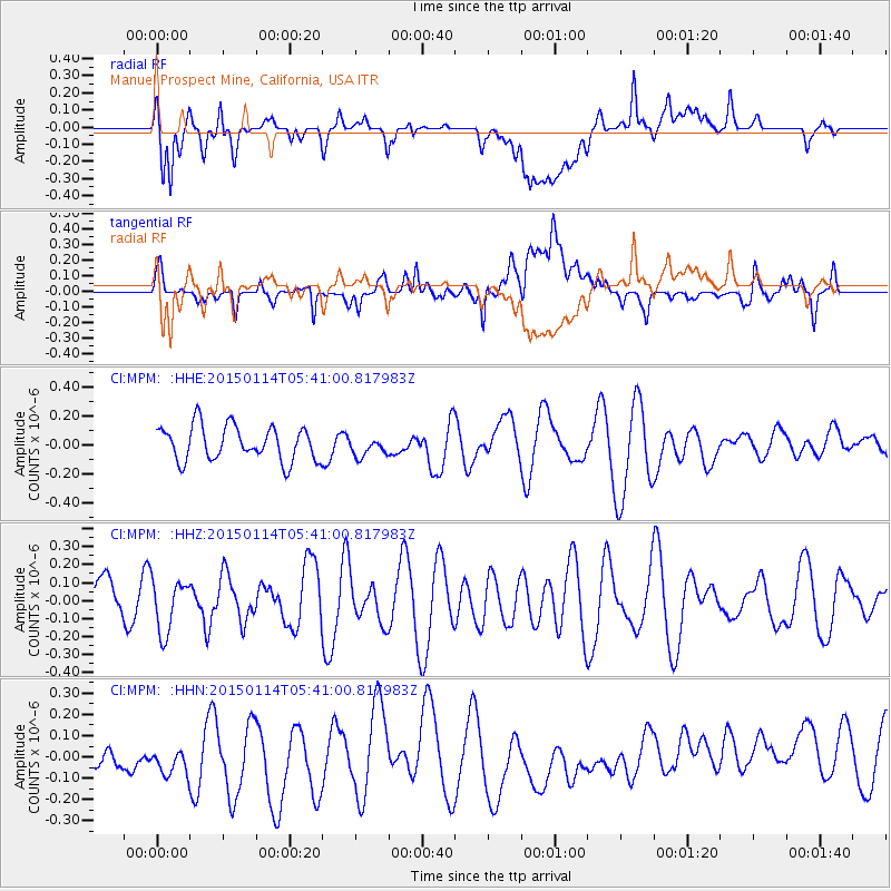
MPM Manuel Prospect Mine, California, USA - Earthquake Result Viewer
*The percent match for this event was below the threshold and hence no stack was calculated.
| Earthquake location: |
Tonga Islands Region |
| Earthquake latitude/longitude: |
-22.1/-175.6 |
| Earthquake time(UTC): |
2015/01/14 (014) 05:29:34 GMT |
| Earthquake Depth: |
100 km |
| Earthquake Magnitude: |
5.1 MW, 4.7 mb |
| Earthquake Catalog/Contributor: |
ISC/ISC |
|
| Network: |
CI Caltech Regional Seismic Network |
| Station: |
MPM Manuel Prospect Mine, California, USA |
| Lat/Lon: |
36.06 N/117.49 W |
| Elevation: |
185 m |
|
| Distance: |
79.8 deg |
| Az: |
44.341 deg |
| Baz: |
233.104 deg |
| Ray Param: |
$rayparam |
*The percent match for this event was below the threshold and hence was not used in the summary stack. |
|
| Radial Match: |
69.89383 % |
| Radial Bump: |
400 |
| Transverse Match: |
52.693752 % |
| Transverse Bump: |
400 |
| SOD ConfigId: |
3390531 |
| Insert Time: |
2019-04-16 01:18:25.263 +0000 |
| GWidth: |
2.5 |
| Max Bumps: |
400 |
| Tol: |
0.001 |
|
Signal To Noise
| Channel | StoN | STA | LTA |
| CI:MPM: :HHZ:20150114T05:41:00.817983Z | 0.6482773 | 1.450301E-7 | 2.2371616E-7 |
| CI:MPM: :HHN:20150114T05:41:00.817983Z | 0.86894846 | 1.5438737E-7 | 1.7767148E-7 |
| CI:MPM: :HHE:20150114T05:41:00.817983Z | 0.55507606 | 6.631762E-8 | 1.1947483E-7 |
| Arrivals |
| Ps | |
| PpPs | |
| PsPs/PpSs | |


