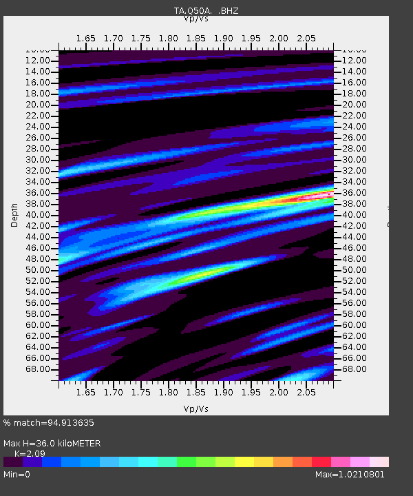
Q50A Georgetown, OH, USA - Earthquake Result Viewer
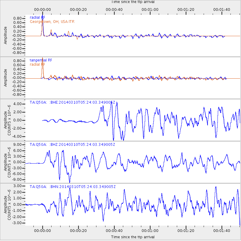
Earthquake location: Off Coast Of Northern California
Earthquake latitude/longitude: 40.8/-125.1
Earthquake time(UTC): 2014/03/10 (069) 05:18:13 GMT
Earthquake Depth: 17 km
Earthquake Magnitude: 6.8 MW, 6.8 MWR, 6.9 MWW, 6.9 MWB, 7.0 MI, 7.0 MWC
Earthquake Catalog/Contributor: NEIC PDE/NEIC COMCAT
Network: TA USArray Transportable Network (new EarthScope stations)
Station: Q50A Georgetown, OH, USA
Lat/Lon: 38.84 N/83.98 W
Elevation: 262 m
Distance: 31.5 deg
Az: 79.952 deg
Baz: 286.898 deg
Ray Param: 0.07905406
Estimated Moho Depth: 36.0 km
Estimated Crust Vp/Vs: 2.09
Assumed Crust Vp: 6.232 km/s
Estimated Crust Vs: 2.982 km/s
Estimated Crust Poisson's Ratio: 0.35
Radial Match: 94.913635 %
Radial Bump: 367
Transverse Match: 76.940315 %
Transverse Bump: 400
SOD ConfigId: 626651
Insert Time: 2014-04-21 03:16:42.231 +0000
GWidth: 2.5
Max Bumps: 400
Tol: 0.001

Signal To Noise

ChannelStoNSTALTA
TA:Q50A: :BHZ:20140310T05:24:03.349005Z19.318063.0831936E-61.5960163E-7
TA:Q50A: :BHN:20140310T05:24:03.349005Z6.6904916.336344E-79.47067E-8
TA:Q50A: :BHE:20140310T05:24:03.349005Z9.3660821.9273386E-62.0577853E-7
Arrivals
Ps6.7 SECOND
PpPs17 SECOND
PsPs/PpSs23 SECOND