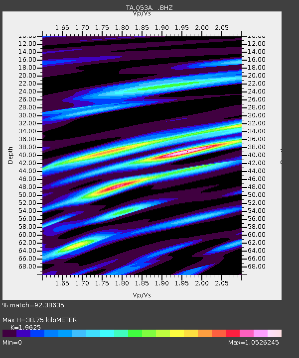
Q53A Leroy, WV, USA - Earthquake Result Viewer
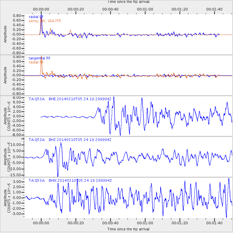
Earthquake location: Off Coast Of Northern California
Earthquake latitude/longitude: 40.8/-125.1
Earthquake time(UTC): 2014/03/10 (069) 05:18:13 GMT
Earthquake Depth: 17 km
Earthquake Magnitude: 6.8 MW, 6.8 MWR, 6.9 MWW, 6.9 MWB, 7.0 MI, 7.0 MWC
Earthquake Catalog/Contributor: NEIC PDE/NEIC COMCAT
Network: TA USArray Transportable Network (new EarthScope stations)
Station: Q53A Leroy, WV, USA
Lat/Lon: 38.86 N/81.53 W
Elevation: 310 m
Distance: 33.3 deg
Az: 78.867 deg
Baz: 287.515 deg
Ray Param: 0.07826305
Estimated Moho Depth: 38.75 km
Estimated Crust Vp/Vs: 1.96
Assumed Crust Vp: 6.207 km/s
Estimated Crust Vs: 3.163 km/s
Estimated Crust Poisson's Ratio: 0.32
Radial Match: 92.38635 %
Radial Bump: 400
Transverse Match: 70.254524 %
Transverse Bump: 400
SOD ConfigId: 626651
Insert Time: 2014-04-21 03:16:50.964 +0000
GWidth: 2.5
Max Bumps: 400
Tol: 0.001

Signal To Noise

ChannelStoNSTALTA
TA:Q53A: :BHZ:20140310T05:24:19.299994Z16.9400083.310507E-61.9542534E-7
TA:Q53A: :BHN:20140310T05:24:19.299994Z4.903635.874637E-71.1980181E-7
TA:Q53A: :BHE:20140310T05:24:19.299994Z11.6687891.9855684E-61.701606E-7
Arrivals
Ps6.4 SECOND
PpPs17 SECOND
PsPs/PpSs24 SECOND