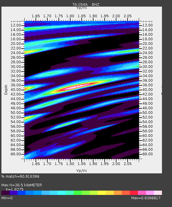
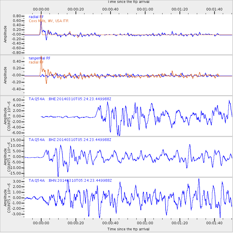
Q54A Coxs Mills, WV, USA - Earthquake Result Viewer

Earthquake location: Off Coast Of Northern California
Earthquake latitude/longitude: 40.8/-125.1
Earthquake time(UTC): 2014/03/10 (069) 05:18:13 GMT
Earthquake Depth: 17 km
Earthquake Magnitude: 6.8 MW, 6.8 MWR, 6.9 MWW, 6.9 MWB, 7.0 MI, 7.0 MWC
Earthquake Catalog/Contributor: NEIC PDE/NEIC COMCAT
Network: TA USArray Transportable Network (new EarthScope stations)
Station: Q54A Coxs Mills, WV, USA
Lat/Lon: 38.98 N/80.83 W
Elevation: 254 m
Distance: 33.8 deg
Az: 78.358 deg
Baz: 287.522 deg
Ray Param: 0.07804361
Estimated Moho Depth: 38.5 km
Estimated Crust Vp/Vs: 1.83
Assumed Crust Vp: 6.207 km/s
Estimated Crust Vs: 3.396 km/s
Estimated Crust Poisson's Ratio: 0.29
Radial Match: 90.918396 %
Radial Bump: 400
Transverse Match: 75.3778 %
Transverse Bump: 400
SOD ConfigId: 626651
Insert Time: 2014-04-21 03:16:51.408 +0000
GWidth: 2.5
Max Bumps: 400
Tol: 0.001

Signal To Noise

ChannelStoNSTALTA
TA:Q54A: :BHZ:20140310T05:24:23.449988Z18.0783423.350257E-61.8531881E-7
TA:Q54A: :BHN:20140310T05:24:23.449988Z3.7506055.949986E-71.586407E-7
TA:Q54A: :BHE:20140310T05:24:23.449988Z13.0895322.0362404E-61.5556252E-7
Arrivals
Ps5.5 SECOND
PpPs16 SECOND
PsPs/PpSs22 SECOND