Q59A Harwood, MD, USA - Earthquake Result Viewer
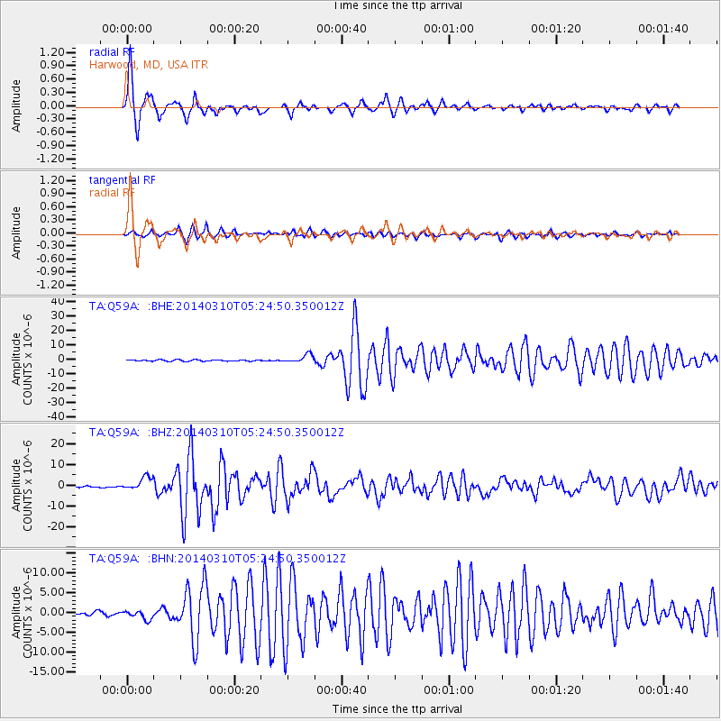
Earthquake location: Off Coast Of Northern California
Earthquake latitude/longitude: 40.8/-125.1
Earthquake time(UTC): 2014/03/10 (069) 05:18:13 GMT
Earthquake Depth: 17 km
Earthquake Magnitude: 6.8 MW, 6.8 MWR, 6.9 MWW, 6.9 MWB, 7.0 MI, 7.0 MWC
Earthquake Catalog/Contributor: NEIC PDE/NEIC COMCAT
Network: TA USArray Transportable Network (new EarthScope stations)
Station: Q59A Harwood, MD, USA
Lat/Lon: 38.86 N/76.65 W
Elevation: 34 m
Distance: 36.9 deg
Az: 76.793 deg
Baz: 288.862 deg
Ray Param: 0.07641413
Estimated Moho Depth: 32.25 km
Estimated Crust Vp/Vs: 1.74
Assumed Crust Vp: 6.419 km/s
Estimated Crust Vs: 3.695 km/s
Estimated Crust Poisson's Ratio: 0.25
Radial Match: 93.35423 %
Radial Bump: 347
Transverse Match: 85.31722 %
Transverse Bump: 400
SOD ConfigId: 626651
Insert Time: 2014-04-21 03:17:06.188 +0000
GWidth: 2.5
Max Bumps: 400
Tol: 0.001

Signal To Noise

ChannelStoNSTALTA
TA:Q59A: :BHZ:20140310T05:24:50.350012Z11.2684273.2819955E-62.9125587E-7
TA:Q59A: :BHN:20140310T05:24:50.350012Z2.8095441.1471873E-64.0831796E-7
TA:Q59A: :BHE:20140310T05:24:50.350012Z6.25887632.8786208E-64.5992616E-7
Arrivals
Ps4.0 SECOND
PpPs13 SECOND
PsPs/PpSs17 SECOND