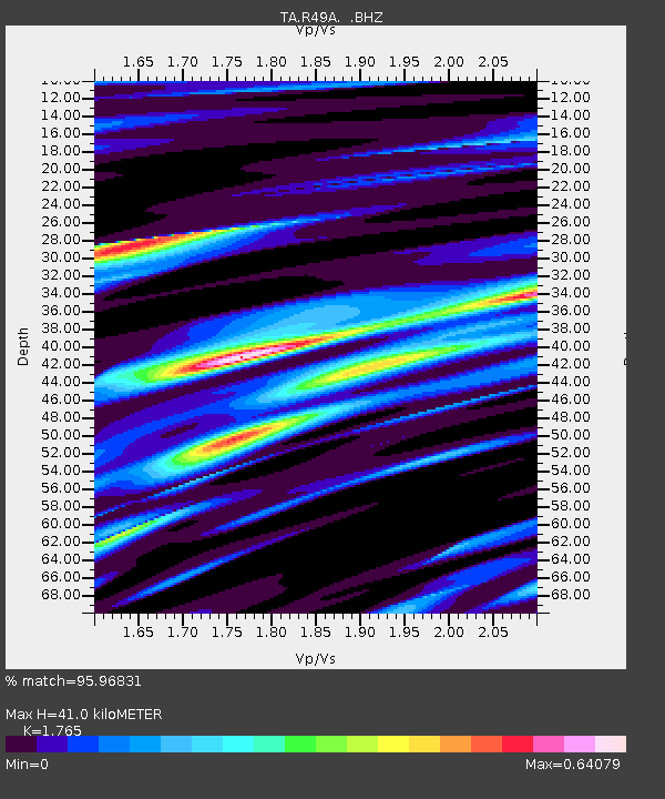
R49A Shelbyville, KY, USA - Earthquake Result Viewer

Earthquake location: Off Coast Of Northern California
Earthquake latitude/longitude: 40.8/-125.1
Earthquake time(UTC): 2014/03/10 (069) 05:18:13 GMT
Earthquake Depth: 17 km
Earthquake Magnitude: 6.8 MW, 6.8 MWR, 6.9 MWW, 6.9 MWB, 7.0 MI, 7.0 MWC
Earthquake Catalog/Contributor: NEIC PDE/NEIC COMCAT
Network: TA USArray Transportable Network (new EarthScope stations)
Station: R49A Shelbyville, KY, USA
Lat/Lon: 38.29 N/85.17 W
Elevation: 251 m
Distance: 30.7 deg
Az: 81.507 deg
Baz: 287.489 deg
Ray Param: 0.07924697
Estimated Moho Depth: 41.0 km
Estimated Crust Vp/Vs: 1.76
Assumed Crust Vp: 6.498 km/s
Estimated Crust Vs: 3.681 km/s
Estimated Crust Poisson's Ratio: 0.26
Radial Match: 95.96831 %
Radial Bump: 286
Transverse Match: 85.0592 %
Transverse Bump: 400
SOD ConfigId: 626651
Insert Time: 2014-04-21 03:17:10.592 +0000
GWidth: 2.5
Max Bumps: 400
Tol: 0.001

Signal To Noise

ChannelStoNSTALTA
TA:R49A: :BHZ:20140310T05:23:56.924994Z16.361253.1915076E-61.9506503E-7
TA:R49A: :BHN:20140310T05:23:56.924994Z8.01909357.121614E-78.8808214E-8
TA:R49A: :BHE:20140310T05:23:56.924994Z17.493232.0318632E-61.16151405E-7
Arrivals
Ps5.2 SECOND
PpPs16 SECOND
PsPs/PpSs21 SECOND