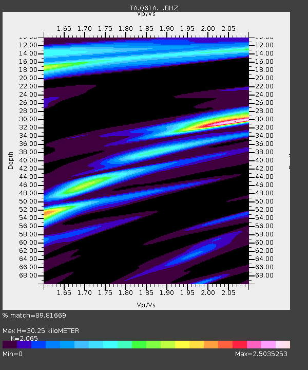
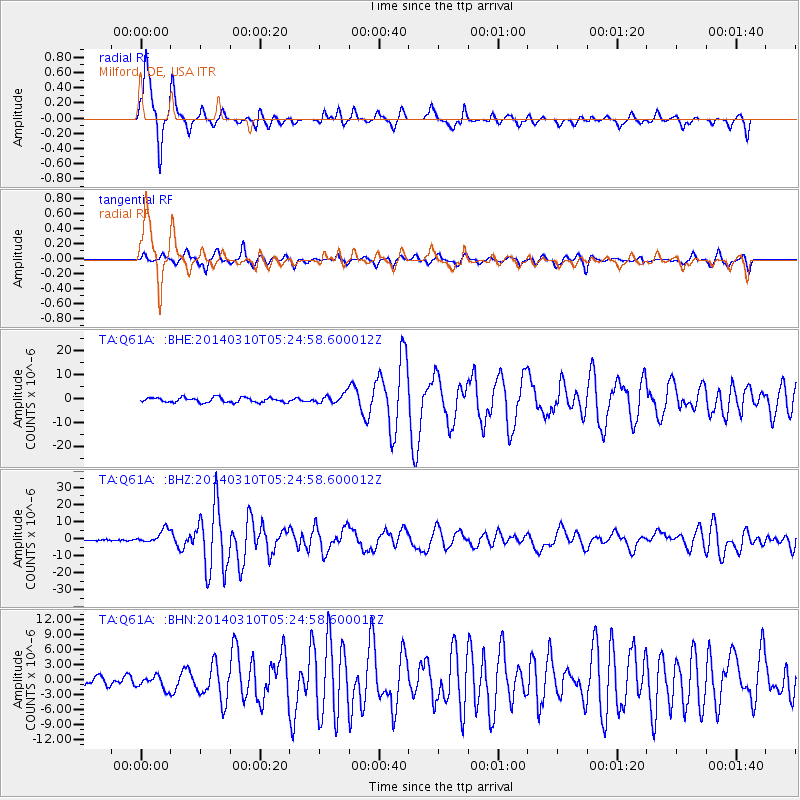
Q61A Milford, DE, USA - Earthquake Result Viewer

Earthquake location: Off Coast Of Northern California
Earthquake latitude/longitude: 40.8/-125.1
Earthquake time(UTC): 2014/03/10 (069) 05:18:13 GMT
Earthquake Depth: 17 km
Earthquake Magnitude: 6.8 MW, 6.8 MWR, 6.9 MWW, 6.9 MWB, 7.0 MI, 7.0 MWC
Earthquake Catalog/Contributor: NEIC PDE/NEIC COMCAT
Network: TA USArray Transportable Network (new EarthScope stations)
Station: Q61A Milford, DE, USA
Lat/Lon: 38.88 N/75.33 W
Elevation: 5.0 m
Distance: 37.9 deg
Az: 76.212 deg
Baz: 289.23 deg
Ray Param: 0.075871624
Estimated Moho Depth: 30.25 km
Estimated Crust Vp/Vs: 2.07
Assumed Crust Vp: 6.287 km/s
Estimated Crust Vs: 3.045 km/s
Estimated Crust Poisson's Ratio: 0.35
Radial Match: 89.81669 %
Radial Bump: 273
Transverse Match: 77.49036 %
Transverse Bump: 362
SOD ConfigId: 626651
Insert Time: 2014-04-21 03:17:10.705 +0000
GWidth: 2.5
Max Bumps: 400
Tol: 0.001

Signal To Noise

ChannelStoNSTALTA
TA:Q61A: :BHZ:20140310T05:24:58.600012Z9.50645353.8979356E-64.1003048E-7
TA:Q61A: :BHN:20140310T05:24:58.600012Z1.90869651.3071021E-66.8481404E-7
TA:Q61A: :BHE:20140310T05:24:58.600012Z1.99182051.9379447E-69.729515E-7
Arrivals
Ps5.4 SECOND
PpPs14 SECOND
PsPs/PpSs19 SECOND