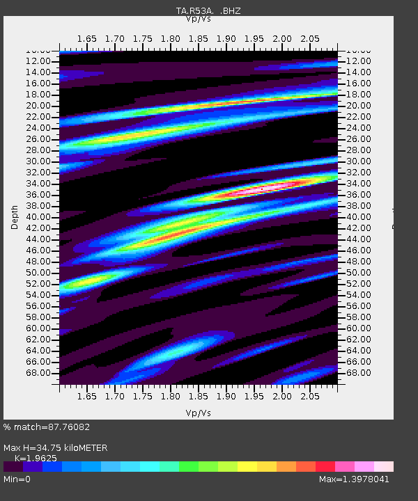
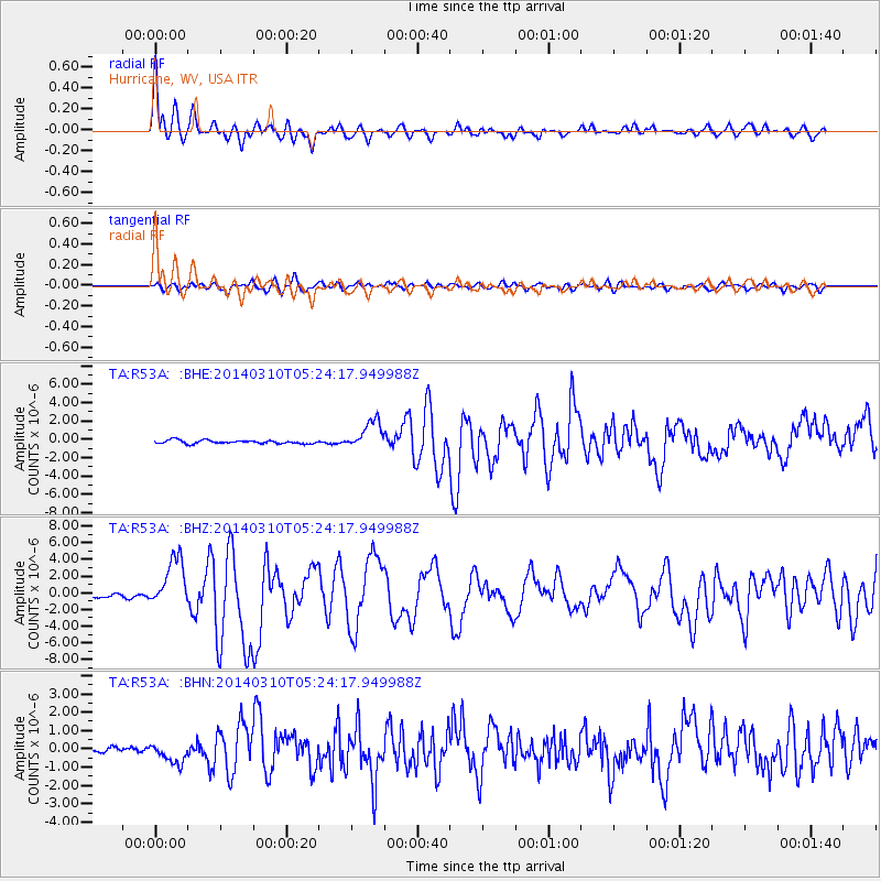
R53A Hurricane, WV, USA - Earthquake Result Viewer

Earthquake location: Off Coast Of Northern California
Earthquake latitude/longitude: 40.8/-125.1
Earthquake time(UTC): 2014/03/10 (069) 05:18:13 GMT
Earthquake Depth: 17 km
Earthquake Magnitude: 6.8 MW, 6.8 MWR, 6.9 MWW, 6.9 MWB, 7.0 MI, 7.0 MWC
Earthquake Catalog/Contributor: NEIC PDE/NEIC COMCAT
Network: TA USArray Transportable Network (new EarthScope stations)
Station: R53A Hurricane, WV, USA
Lat/Lon: 38.33 N/81.95 W
Elevation: 294 m
Distance: 33.1 deg
Az: 79.97 deg
Baz: 288.173 deg
Ray Param: 0.07833509
Estimated Moho Depth: 34.75 km
Estimated Crust Vp/Vs: 1.96
Assumed Crust Vp: 6.207 km/s
Estimated Crust Vs: 3.163 km/s
Estimated Crust Poisson's Ratio: 0.32
Radial Match: 87.76082 %
Radial Bump: 400
Transverse Match: 68.82353 %
Transverse Bump: 400
SOD ConfigId: 626651
Insert Time: 2014-04-21 03:17:21.155 +0000
GWidth: 2.5
Max Bumps: 400
Tol: 0.001

Signal To Noise

ChannelStoNSTALTA
TA:R53A: :BHZ:20140310T05:24:17.949988Z13.3314643.016762E-62.2628889E-7
TA:R53A: :BHN:20140310T05:24:17.949988Z3.70742585.6697223E-71.5292882E-7
TA:R53A: :BHE:20140310T05:24:17.949988Z8.6042421.5630003E-61.8165461E-7
Arrivals
Ps5.8 SECOND
PpPs16 SECOND
PsPs/PpSs21 SECOND