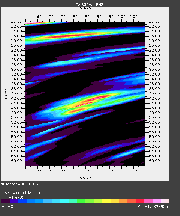
R55A Marlinton, WV, USA - Earthquake Result Viewer

Earthquake location: Off Coast Of Northern California
Earthquake latitude/longitude: 40.8/-125.1
Earthquake time(UTC): 2014/03/10 (069) 05:18:13 GMT
Earthquake Depth: 17 km
Earthquake Magnitude: 6.8 MW, 6.8 MWR, 6.9 MWW, 6.9 MWB, 7.0 MI, 7.0 MWC
Earthquake Catalog/Contributor: NEIC PDE/NEIC COMCAT
Network: TA USArray Transportable Network (new EarthScope stations)
Station: R55A Marlinton, WV, USA
Lat/Lon: 38.28 N/80.12 W
Elevation: 833 m
Distance: 34.5 deg
Az: 79.233 deg
Baz: 288.691 deg
Ray Param: 0.07768729
Estimated Moho Depth: 10.0 km
Estimated Crust Vp/Vs: 1.63
Assumed Crust Vp: 6.207 km/s
Estimated Crust Vs: 3.802 km/s
Estimated Crust Poisson's Ratio: 0.20
Radial Match: 96.16804 %
Radial Bump: 400
Transverse Match: 92.33945 %
Transverse Bump: 400
SOD ConfigId: 626651
Insert Time: 2014-04-21 03:17:25.890 +0000
GWidth: 2.5
Max Bumps: 400
Tol: 0.001

Signal To Noise

ChannelStoNSTALTA
TA:R55A: :BHZ:20140310T05:24:29.924994Z22.5405163.871233E-61.7174553E-7
TA:R55A: :BHN:20140310T05:24:29.924994Z6.0679648.5223274E-71.4044788E-7
TA:R55A: :BHE:20140310T05:24:29.924994Z16.3234142.532835E-61.5516576E-7
Arrivals
Ps1.1 SECOND
PpPs3.9 SECOND
PsPs/PpSs5.0 SECOND