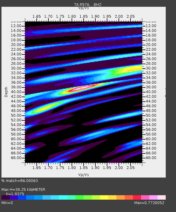
R57A Stanardsville, VA, USA - Earthquake Result Viewer

Earthquake location: Off Coast Of Northern California
Earthquake latitude/longitude: 40.8/-125.1
Earthquake time(UTC): 2014/03/10 (069) 05:18:13 GMT
Earthquake Depth: 17 km
Earthquake Magnitude: 6.8 MW, 6.8 MWR, 6.9 MWW, 6.9 MWB, 7.0 MI, 7.0 MWC
Earthquake Catalog/Contributor: NEIC PDE/NEIC COMCAT
Network: TA USArray Transportable Network (new EarthScope stations)
Station: R57A Stanardsville, VA, USA
Lat/Lon: 38.30 N/78.52 W
Elevation: 230 m
Distance: 35.7 deg
Az: 78.503 deg
Baz: 289.079 deg
Ray Param: 0.07706783
Estimated Moho Depth: 38.25 km
Estimated Crust Vp/Vs: 1.84
Assumed Crust Vp: 6.159 km/s
Estimated Crust Vs: 3.352 km/s
Estimated Crust Poisson's Ratio: 0.29
Radial Match: 96.08063 %
Radial Bump: 257
Transverse Match: 76.20284 %
Transverse Bump: 400
SOD ConfigId: 626651
Insert Time: 2014-04-21 03:17:29.943 +0000
GWidth: 2.5
Max Bumps: 400
Tol: 0.001

Signal To Noise

ChannelStoNSTALTA
TA:R57A: :BHZ:20140310T05:24:40.100012Z16.18433.138167E-61.9390194E-7
TA:R57A: :BHN:20140310T05:24:40.100012Z3.71395285.797264E-71.5609419E-7
TA:R57A: :BHE:20140310T05:24:40.100012Z12.3446521.9247777E-61.5591996E-7
Arrivals
Ps5.6 SECOND
PpPs16 SECOND
PsPs/PpSs22 SECOND