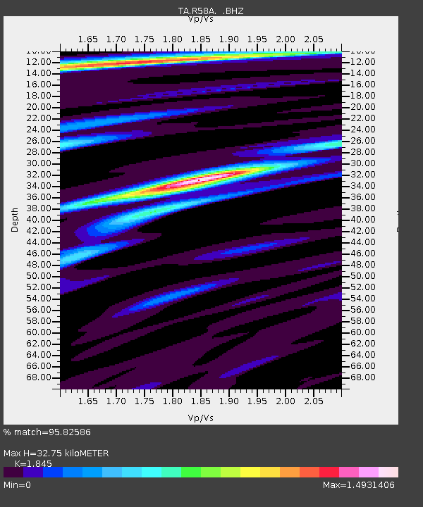
R58A Rapidan, VA, USA - Earthquake Result Viewer
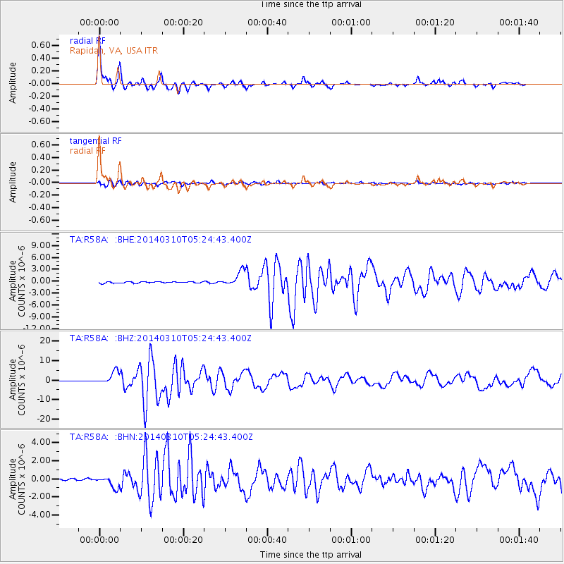
Earthquake location: Off Coast Of Northern California
Earthquake latitude/longitude: 40.8/-125.1
Earthquake time(UTC): 2014/03/10 (069) 05:18:13 GMT
Earthquake Depth: 17 km
Earthquake Magnitude: 6.8 MW, 6.8 MWR, 6.9 MWW, 6.9 MWB, 7.0 MI, 7.0 MWC
Earthquake Catalog/Contributor: NEIC PDE/NEIC COMCAT
Network: TA USArray Transportable Network (new EarthScope stations)
Station: R58A Rapidan, VA, USA
Lat/Lon: 38.30 N/78.00 W
Elevation: 184 m
Distance: 36.1 deg
Az: 78.271 deg
Baz: 289.212 deg
Ray Param: 0.07685802
Estimated Moho Depth: 32.75 km
Estimated Crust Vp/Vs: 1.85
Assumed Crust Vp: 6.159 km/s
Estimated Crust Vs: 3.338 km/s
Estimated Crust Poisson's Ratio: 0.29
Radial Match: 95.82586 %
Radial Bump: 276
Transverse Match: 86.30146 %
Transverse Bump: 400
SOD ConfigId: 626651
Insert Time: 2014-04-21 03:17:34.115 +0000
GWidth: 2.5
Max Bumps: 400
Tol: 0.001

Signal To Noise

ChannelStoNSTALTA
TA:R58A: :BHZ:20140310T05:24:43.400Z31.098083.2997286E-61.0610715E-7
TA:R58A: :BHN:20140310T05:24:43.400Z5.6881656.223128E-71.0940484E-7
TA:R58A: :BHE:20140310T05:24:43.400Z11.0540791.9387978E-61.7539209E-7
Arrivals
Ps4.8 SECOND
PpPs14 SECOND
PsPs/PpSs19 SECOND