S50A Richmond, KY, USA - Earthquake Result Viewer
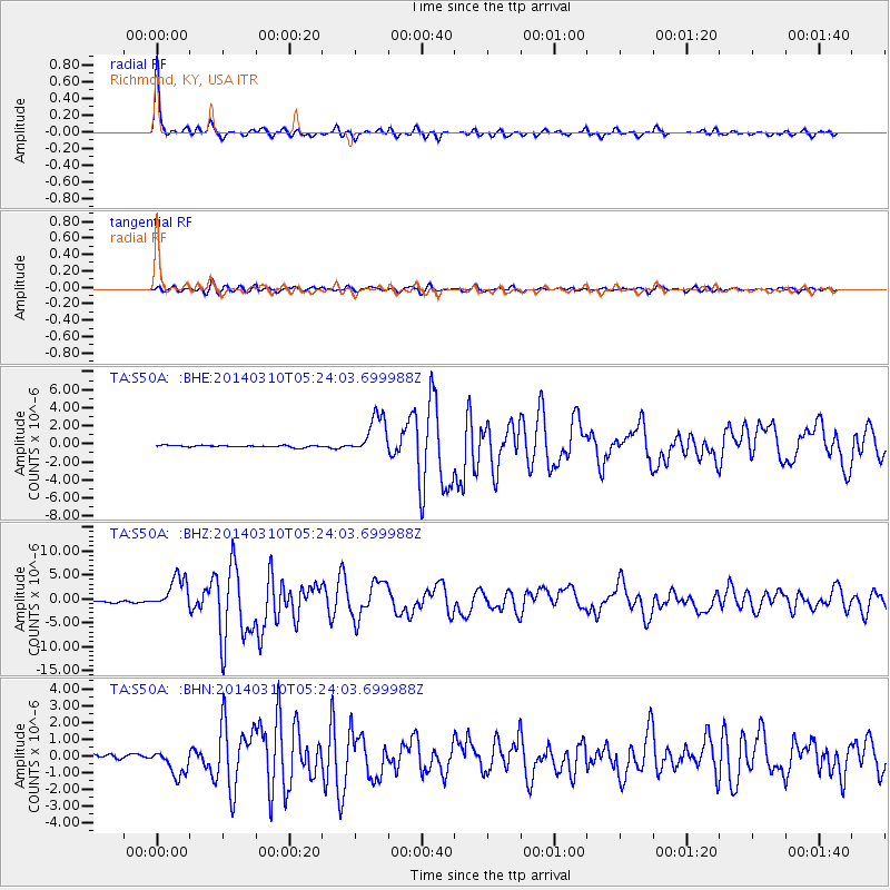
Earthquake location: Off Coast Of Northern California
Earthquake latitude/longitude: 40.8/-125.1
Earthquake time(UTC): 2014/03/10 (069) 05:18:13 GMT
Earthquake Depth: 17 km
Earthquake Magnitude: 6.8 MW, 6.8 MWR, 6.9 MWW, 6.9 MWB, 7.0 MI, 7.0 MWC
Earthquake Catalog/Contributor: NEIC PDE/NEIC COMCAT
Network: TA USArray Transportable Network (new EarthScope stations)
Station: S50A Richmond, KY, USA
Lat/Lon: 37.68 N/84.40 W
Elevation: 300 m
Distance: 31.5 deg
Az: 82.267 deg
Baz: 288.612 deg
Ray Param: 0.07903759
Estimated Moho Depth: 50.0 km
Estimated Crust Vp/Vs: 2.02
Assumed Crust Vp: 6.476 km/s
Estimated Crust Vs: 3.214 km/s
Estimated Crust Poisson's Ratio: 0.34
Radial Match: 97.02793 %
Radial Bump: 302
Transverse Match: 76.99937 %
Transverse Bump: 400
SOD ConfigId: 626651
Insert Time: 2014-04-21 03:17:47.530 +0000
GWidth: 2.5
Max Bumps: 400
Tol: 0.001

Signal To Noise

ChannelStoNSTALTA
TA:S50A: :BHZ:20140310T05:24:03.699988Z19.2769153.394094E-61.7607039E-7
TA:S50A: :BHN:20140310T05:24:03.699988Z7.0212437.654432E-71.0901819E-7
TA:S50A: :BHE:20140310T05:24:03.699988Z21.6652162.2313416E-61.0299189E-7
Arrivals
Ps8.4 SECOND
PpPs22 SECOND
PsPs/PpSs30 SECOND