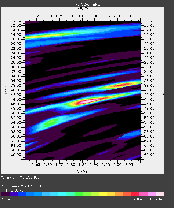
T52A Hallie, KY, USA - Earthquake Result Viewer
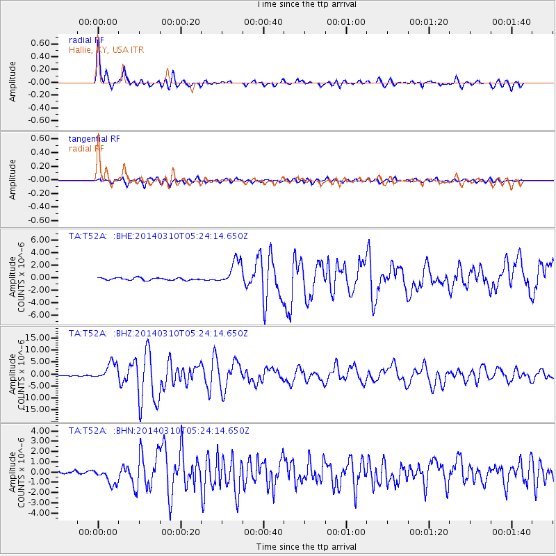
Earthquake location: Off Coast Of Northern California
Earthquake latitude/longitude: 40.8/-125.1
Earthquake time(UTC): 2014/03/10 (069) 05:18:13 GMT
Earthquake Depth: 17 km
Earthquake Magnitude: 6.8 MW, 6.8 MWR, 6.9 MWW, 6.9 MWB, 7.0 MI, 7.0 MWC
Earthquake Catalog/Contributor: NEIC PDE/NEIC COMCAT
Network: TA USArray Transportable Network (new EarthScope stations)
Station: T52A Hallie, KY, USA
Lat/Lon: 37.11 N/82.99 W
Elevation: 436 m
Distance: 32.8 deg
Az: 82.583 deg
Baz: 289.736 deg
Ray Param: 0.078505345
Estimated Moho Depth: 44.5 km
Estimated Crust Vp/Vs: 1.88
Assumed Crust Vp: 6.476 km/s
Estimated Crust Vs: 3.449 km/s
Estimated Crust Poisson's Ratio: 0.30
Radial Match: 91.532486 %
Radial Bump: 400
Transverse Match: 79.67967 %
Transverse Bump: 400
SOD ConfigId: 626651
Insert Time: 2014-04-21 03:18:21.999 +0000
GWidth: 2.5
Max Bumps: 400
Tol: 0.001

Signal To Noise

ChannelStoNSTALTA
TA:T52A: :BHZ:20140310T05:24:14.650Z27.349743.7854516E-61.3840905E-7
TA:T52A: :BHN:20140310T05:24:14.650Z5.03667458.2642595E-71.6408167E-7
TA:T52A: :BHE:20140310T05:24:14.650Z11.2393222.0998443E-61.8683015E-7
Arrivals
Ps6.5 SECOND
PpPs18 SECOND
PsPs/PpSs25 SECOND