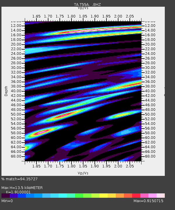
T55A Pulaski, VA, USA - Earthquake Result Viewer

Earthquake location: Off Coast Of Northern California
Earthquake latitude/longitude: 40.8/-125.1
Earthquake time(UTC): 2014/03/10 (069) 05:18:13 GMT
Earthquake Depth: 17 km
Earthquake Magnitude: 6.8 MW, 6.8 MWR, 6.9 MWW, 6.9 MWB, 7.0 MI, 7.0 MWC
Earthquake Catalog/Contributor: NEIC PDE/NEIC COMCAT
Network: TA USArray Transportable Network (new EarthScope stations)
Station: T55A Pulaski, VA, USA
Lat/Lon: 37.12 N/80.78 W
Elevation: 644 m
Distance: 34.4 deg
Az: 81.483 deg
Baz: 290.141 deg
Ray Param: 0.077744454
Estimated Moho Depth: 13.5 km
Estimated Crust Vp/Vs: 1.91
Assumed Crust Vp: 6.159 km/s
Estimated Crust Vs: 3.224 km/s
Estimated Crust Poisson's Ratio: 0.31
Radial Match: 94.35727 %
Radial Bump: 400
Transverse Match: 89.43965 %
Transverse Bump: 400
SOD ConfigId: 626651
Insert Time: 2014-04-21 03:18:31.184 +0000
GWidth: 2.5
Max Bumps: 400
Tol: 0.001

Signal To Noise

ChannelStoNSTALTA
TA:T55A: :BHZ:20140310T05:24:28.975012Z17.1359043.9615975E-62.3118696E-7
TA:T55A: :BHN:20140310T05:24:28.975012Z5.97181469.481721E-71.5877454E-7
TA:T55A: :BHE:20140310T05:24:28.975012Z12.0184862.4196115E-62.0132416E-7
Arrivals
Ps2.1 SECOND
PpPs6.0 SECOND
PsPs/PpSs8.1 SECOND