You are here: Home > Network List > TA - USArray Transportable Network (new EarthScope stations) Stations List
> Station U55A TA2, Sparta, NC, USA > Earthquake Result Viewer
U55A TA2, Sparta, NC, USA - Earthquake Result Viewer
| Earthquake location: |
Off Coast Of Northern California |
| Earthquake latitude/longitude: |
40.8/-125.1 |
| Earthquake time(UTC): |
2014/03/10 (069) 05:18:13 GMT |
| Earthquake Depth: |
17 km |
| Earthquake Magnitude: |
6.8 MW, 6.8 MWR, 6.9 MWW, 6.9 MWB, 7.0 MI, 7.0 MWC |
| Earthquake Catalog/Contributor: |
NEIC PDE/NEIC COMCAT |
|
| Network: |
TA USArray Transportable Network (new EarthScope stations) |
| Station: |
U55A TA2, Sparta, NC, USA |
| Lat/Lon: |
36.50 N/81.05 W |
| Elevation: |
863 m |
|
| Distance: |
34.4 deg |
| Az: |
82.63 deg |
| Baz: |
290.931 deg |
| Ray Param: |
0.077735335 |
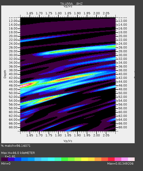
| Estimated Moho Depth: |
46.0 km |
| Estimated Crust Vp/Vs: |
1.61 |
| Assumed Crust Vp: |
6.159 km/s |
| Estimated Crust Vs: |
3.825 km/s |
| Estimated Crust Poisson's Ratio: |
0.19 |
|
| Radial Match: |
96.16071 % |
| Radial Bump: |
364 |
| Transverse Match: |
86.59304 % |
| Transverse Bump: |
400 |
| SOD ConfigId: |
626651 |
| Insert Time: |
2014-04-21 03:18:50.398 +0000 |
| GWidth: |
2.5 |
| Max Bumps: |
400 |
| Tol: |
0.001 |
|
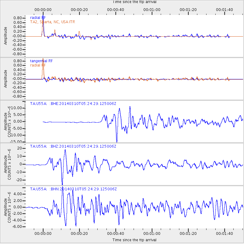
Signal To Noise
| Channel | StoN | STA | LTA |
| TA:U55A: :BHZ:20140310T05:24:29.125006Z | 28.957644 | 3.7590066E-6 | 1.2981052E-7 |
| TA:U55A: :BHN:20140310T05:24:29.125006Z | 8.14933 | 1.039795E-6 | 1.275927E-7 |
| TA:U55A: :BHE:20140310T05:24:29.125006Z | 18.362524 | 2.3125272E-6 | 1.2593732E-7 |
| Arrivals |
| Ps | 4.9 SECOND |
| PpPs | 18 SECOND |
| PsPs/PpSs | 23 SECOND |


