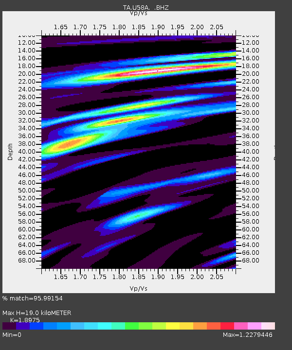
U58A Oxford, NC, USA - Earthquake Result Viewer
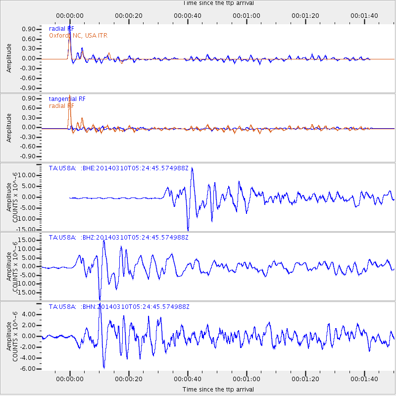
Earthquake location: Off Coast Of Northern California
Earthquake latitude/longitude: 40.8/-125.1
Earthquake time(UTC): 2014/03/10 (069) 05:18:13 GMT
Earthquake Depth: 17 km
Earthquake Magnitude: 6.8 MW, 6.8 MWR, 6.9 MWW, 6.9 MWB, 7.0 MI, 7.0 MWC
Earthquake Catalog/Contributor: NEIC PDE/NEIC COMCAT
Network: TA USArray Transportable Network (new EarthScope stations)
Station: U58A Oxford, NC, USA
Lat/Lon: 36.39 N/78.55 W
Elevation: 169 m
Distance: 36.3 deg
Az: 81.544 deg
Baz: 291.523 deg
Ray Param: 0.07671976
Estimated Moho Depth: 19.0 km
Estimated Crust Vp/Vs: 1.90
Assumed Crust Vp: 6.419 km/s
Estimated Crust Vs: 3.383 km/s
Estimated Crust Poisson's Ratio: 0.31
Radial Match: 95.99154 %
Radial Bump: 288
Transverse Match: 89.05111 %
Transverse Bump: 400
SOD ConfigId: 626651
Insert Time: 2014-04-21 03:18:57.034 +0000
GWidth: 2.5
Max Bumps: 400
Tol: 0.001

Signal To Noise

ChannelStoNSTALTA
TA:U58A: :BHZ:20140310T05:24:45.574988Z16.2896943.4183606E-62.0984805E-7
TA:U58A: :BHN:20140310T05:24:45.574988Z4.27827849.139944E-72.1363603E-7
TA:U58A: :BHE:20140310T05:24:45.574988Z14.6515652.2369168E-61.5267426E-7
Arrivals
Ps2.8 SECOND
PpPs8.0 SECOND
PsPs/PpSs11 SECOND