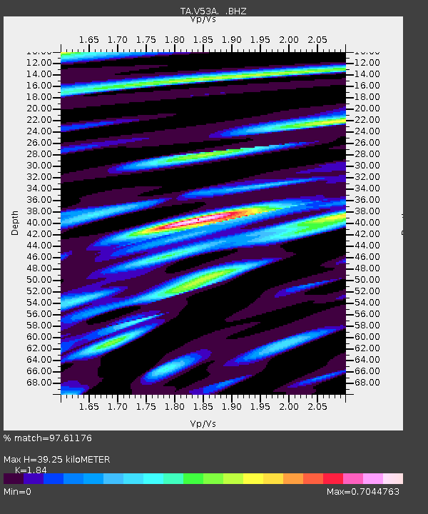
V53A Saluda, NC, USA - Earthquake Result Viewer

Earthquake location: Off Coast Of Northern California
Earthquake latitude/longitude: 40.8/-125.1
Earthquake time(UTC): 2014/03/10 (069) 05:18:13 GMT
Earthquake Depth: 17 km
Earthquake Magnitude: 6.8 MW, 6.8 MWR, 6.9 MWW, 6.9 MWB, 7.0 MI, 7.0 MWC
Earthquake Catalog/Contributor: NEIC PDE/NEIC COMCAT
Network: TA USArray Transportable Network (new EarthScope stations)
Station: V53A Saluda, NC, USA
Lat/Lon: 35.67 N/82.81 W
Elevation: 681 m
Distance: 33.4 deg
Az: 84.952 deg
Baz: 291.823 deg
Ray Param: 0.07821501
Estimated Moho Depth: 39.25 km
Estimated Crust Vp/Vs: 1.84
Assumed Crust Vp: 6.35 km/s
Estimated Crust Vs: 3.451 km/s
Estimated Crust Poisson's Ratio: 0.29
Radial Match: 97.61176 %
Radial Bump: 339
Transverse Match: 89.600586 %
Transverse Bump: 400
SOD ConfigId: 626651
Insert Time: 2014-04-21 03:19:07.661 +0000
GWidth: 2.5
Max Bumps: 400
Tol: 0.001

Signal To Noise

ChannelStoNSTALTA
TA:V53A: :BHZ:20140310T05:24:20.225012Z22.7405573.9667984E-61.7443718E-7
TA:V53A: :BHN:20140310T05:24:20.225012Z7.9264861.0045231E-61.2672994E-7
TA:V53A: :BHE:20140310T05:24:20.225012Z22.7071592.4430635E-61.0759001E-7
Arrivals
Ps5.6 SECOND
PpPs16 SECOND
PsPs/PpSs22 SECOND