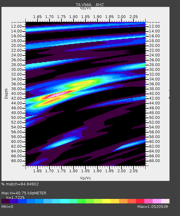
V56A Mocksville, NC, USA - Earthquake Result Viewer
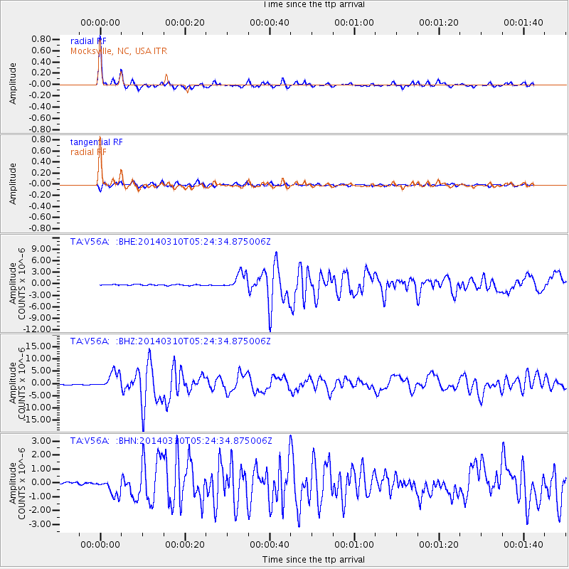
Earthquake location: Off Coast Of Northern California
Earthquake latitude/longitude: 40.8/-125.1
Earthquake time(UTC): 2014/03/10 (069) 05:18:13 GMT
Earthquake Depth: 17 km
Earthquake Magnitude: 6.8 MW, 6.8 MWR, 6.9 MWW, 6.9 MWB, 7.0 MI, 7.0 MWC
Earthquake Catalog/Contributor: NEIC PDE/NEIC COMCAT
Network: TA USArray Transportable Network (new EarthScope stations)
Station: V56A Mocksville, NC, USA
Lat/Lon: 35.81 N/80.50 W
Elevation: 237 m
Distance: 35.1 deg
Az: 83.473 deg
Baz: 291.947 deg
Ray Param: 0.07739023
Estimated Moho Depth: 40.75 km
Estimated Crust Vp/Vs: 1.72
Assumed Crust Vp: 6.419 km/s
Estimated Crust Vs: 3.727 km/s
Estimated Crust Poisson's Ratio: 0.25
Radial Match: 94.94902 %
Radial Bump: 261
Transverse Match: 84.96894 %
Transverse Bump: 400
SOD ConfigId: 626651
Insert Time: 2014-04-21 03:19:15.009 +0000
GWidth: 2.5
Max Bumps: 400
Tol: 0.001

Signal To Noise

ChannelStoNSTALTA
TA:V56A: :BHZ:20140310T05:24:34.875006Z18.6897133.5484313E-61.8986013E-7
TA:V56A: :BHN:20140310T05:24:34.875006Z5.92560966.090122E-71.02776305E-7
TA:V56A: :BHE:20140310T05:24:34.875006Z17.4206522.2026522E-61.2643915E-7
Arrivals
Ps5.0 SECOND
PpPs16 SECOND
PsPs/PpSs21 SECOND