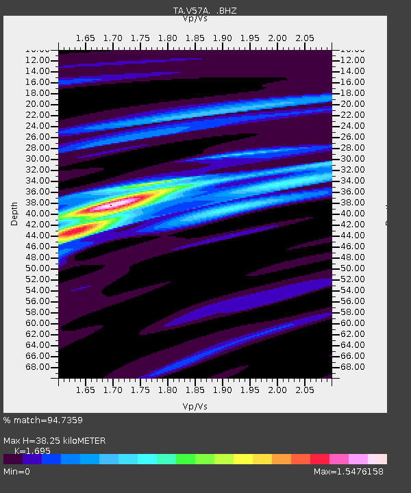
V57A Coltrane Farms, NC, USA - Earthquake Result Viewer

Earthquake location: Off Coast Of Northern California
Earthquake latitude/longitude: 40.8/-125.1
Earthquake time(UTC): 2014/03/10 (069) 05:18:13 GMT
Earthquake Depth: 17 km
Earthquake Magnitude: 6.8 MW, 6.8 MWR, 6.9 MWW, 6.9 MWB, 7.0 MI, 7.0 MWC
Earthquake Catalog/Contributor: NEIC PDE/NEIC COMCAT
Network: TA USArray Transportable Network (new EarthScope stations)
Station: V57A Coltrane Farms, NC, USA
Lat/Lon: 35.89 N/79.78 W
Elevation: 223 m
Distance: 35.6 deg
Az: 82.97 deg
Baz: 291.957 deg
Ray Param: 0.077119194
Estimated Moho Depth: 38.25 km
Estimated Crust Vp/Vs: 1.70
Assumed Crust Vp: 6.565 km/s
Estimated Crust Vs: 3.873 km/s
Estimated Crust Poisson's Ratio: 0.23
Radial Match: 94.7359 %
Radial Bump: 312
Transverse Match: 84.20738 %
Transverse Bump: 400
SOD ConfigId: 626651
Insert Time: 2014-04-21 03:19:16.686 +0000
GWidth: 2.5
Max Bumps: 400
Tol: 0.001

Signal To Noise

ChannelStoNSTALTA
TA:V57A: :BHZ:20140310T05:24:39.299994Z27.1963163.1492714E-61.15797725E-7
TA:V57A: :BHN:20140310T05:24:39.299994Z5.571245.800239E-71.0411038E-7
TA:V57A: :BHE:20140310T05:24:39.299994Z14.7242171.9363308E-61.3150654E-7
Arrivals
Ps4.4 SECOND
PpPs14 SECOND
PsPs/PpSs19 SECOND