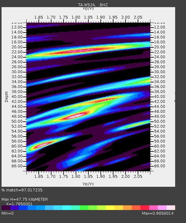
W52A Murphy, NC, USA - Earthquake Result Viewer
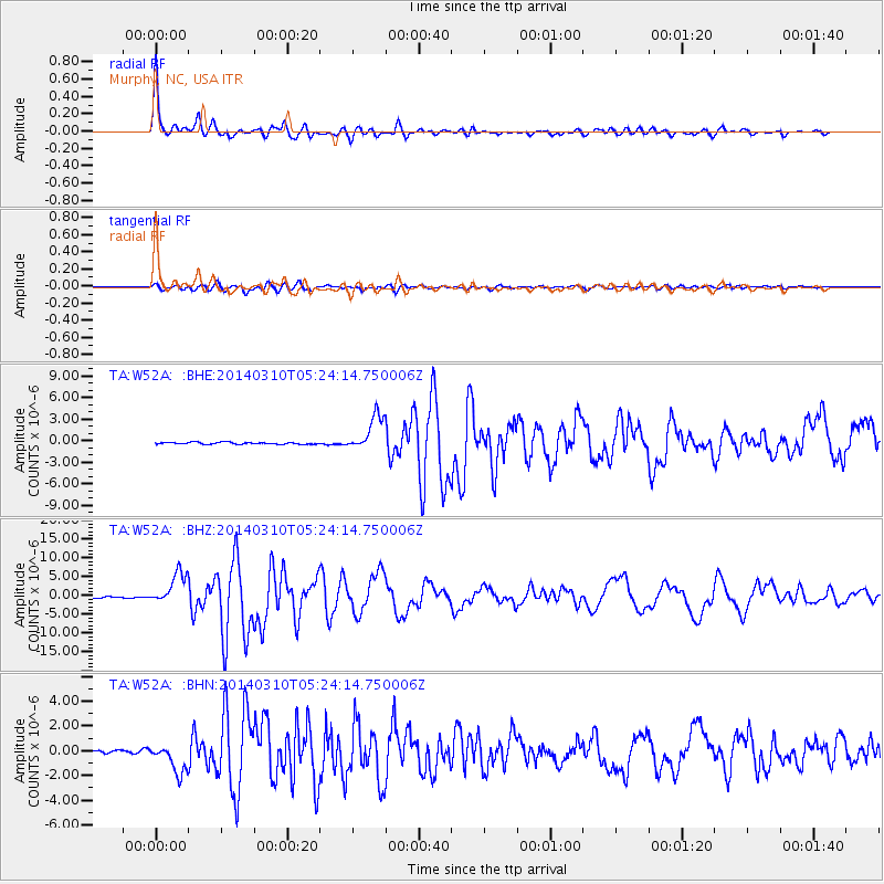
Earthquake location: Off Coast Of Northern California
Earthquake latitude/longitude: 40.8/-125.1
Earthquake time(UTC): 2014/03/10 (069) 05:18:13 GMT
Earthquake Depth: 17 km
Earthquake Magnitude: 6.8 MW, 6.8 MWR, 6.9 MWW, 6.9 MWB, 7.0 MI, 7.0 MWC
Earthquake Catalog/Contributor: NEIC PDE/NEIC COMCAT
Network: TA USArray Transportable Network (new EarthScope stations)
Station: W52A Murphy, NC, USA
Lat/Lon: 35.09 N/83.93 W
Elevation: 519 m
Distance: 32.8 deg
Az: 86.557 deg
Baz: 292.525 deg
Ray Param: 0.0785
Estimated Moho Depth: 47.75 km
Estimated Crust Vp/Vs: 1.80
Assumed Crust Vp: 6.35 km/s
Estimated Crust Vs: 3.538 km/s
Estimated Crust Poisson's Ratio: 0.27
Radial Match: 97.017235 %
Radial Bump: 400
Transverse Match: 89.90148 %
Transverse Bump: 400
SOD ConfigId: 626651
Insert Time: 2014-04-21 03:19:31.104 +0000
GWidth: 2.5
Max Bumps: 400
Tol: 0.001

Signal To Noise

ChannelStoNSTALTA
TA:W52A: :BHZ:20140310T05:24:14.750006Z21.814544.2309157E-61.9394933E-7
TA:W52A: :BHN:20140310T05:24:14.750006Z14.8390621.1704393E-67.887556E-8
TA:W52A: :BHE:20140310T05:24:14.750006Z18.5750352.4743044E-61.3320592E-7
Arrivals
Ps6.4 SECOND
PpPs19 SECOND
PsPs/PpSs26 SECOND