You are here: Home > Network List > TA - USArray Transportable Network (new EarthScope stations) Stations List
> Station X55A Gracelyn & Ava, Whitmire, SC, USA > Earthquake Result Viewer
X55A Gracelyn & Ava, Whitmire, SC, USA - Earthquake Result Viewer

| Earthquake location: |
Off Coast Of Northern California |
| Earthquake latitude/longitude: |
40.8/-125.1 |
| Earthquake time(UTC): |
2014/03/10 (069) 05:18:13 GMT |
| Earthquake Depth: |
17 km |
| Earthquake Magnitude: |
6.8 MW, 6.8 MWR, 6.9 MWW, 6.9 MWB, 7.0 MI, 7.0 MWC |
| Earthquake Catalog/Contributor: |
NEIC PDE/NEIC COMCAT |
|
| Network: |
TA USArray Transportable Network (new EarthScope stations) |
| Station: |
X55A Gracelyn & Ava, Whitmire, SC, USA |
| Lat/Lon: |
34.47 N/81.63 W |
| Elevation: |
153 m |
|
| Distance: |
34.7 deg |
| Az: |
86.256 deg |
| Baz: |
293.578 deg |
| Ray Param: |
0.077567264 |
| Estimated Moho Depth: |
37.75 km |
| Estimated Crust Vp/Vs: |
1.72 |
| Assumed Crust Vp: |
6.419 km/s |
| Estimated Crust Vs: |
3.727 km/s |
| Estimated Crust Poisson's Ratio: |
0.25 |
|
| Radial Match: |
97.60799 % |
| Radial Bump: |
267 |
| Transverse Match: |
86.34481 % |
| Transverse Bump: |
400 |
| SOD ConfigId: |
626651 |
| Insert Time: |
2014-04-21 03:19:53.918 +0000 |
| GWidth: |
2.5 |
| Max Bumps: |
400 |
| Tol: |
0.001 |
|
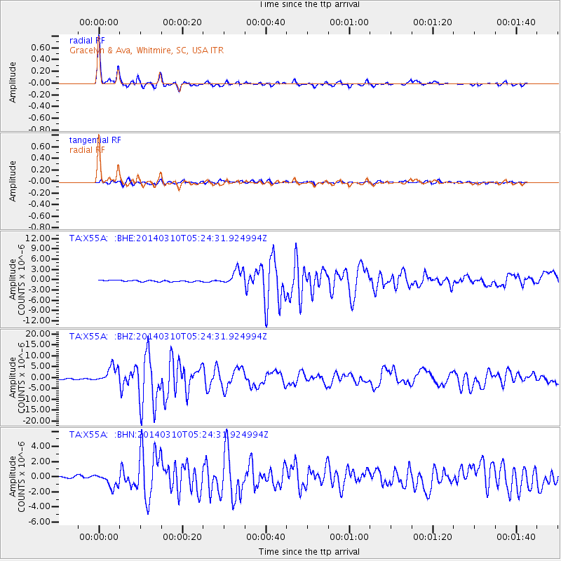
Signal To Noise
| Channel | StoN | STA | LTA |
| TA:X55A: :BHZ:20140310T05:24:31.924994Z | 17.760956 | 4.0065124E-6 | 2.2557978E-7 |
| TA:X55A: :BHN:20140310T05:24:31.924994Z | 6.7171116 | 9.4632594E-7 | 1.4088286E-7 |
| TA:X55A: :BHE:20140310T05:24:31.924994Z | 12.888336 | 2.3937257E-6 | 1.8572806E-7 |
| Arrivals |
| Ps | 4.6 SECOND |
| PpPs | 15 SECOND |
| PsPs/PpSs | 19 SECOND |


