You are here: Home > Network List > TA - USArray Transportable Network (new EarthScope stations) Stations List
> Station X57A Johnson Farm, Hartsville, SC, USA > Earthquake Result Viewer
X57A Johnson Farm, Hartsville, SC, USA - Earthquake Result Viewer
| Earthquake location: |
Off Coast Of Northern California |
| Earthquake latitude/longitude: |
40.8/-125.1 |
| Earthquake time(UTC): |
2014/03/10 (069) 05:18:13 GMT |
| Earthquake Depth: |
17 km |
| Earthquake Magnitude: |
6.8 MW, 6.8 MWR, 6.9 MWW, 6.9 MWB, 7.0 MI, 7.0 MWC |
| Earthquake Catalog/Contributor: |
NEIC PDE/NEIC COMCAT |
|
| Network: |
TA USArray Transportable Network (new EarthScope stations) |
| Station: |
X57A Johnson Farm, Hartsville, SC, USA |
| Lat/Lon: |
34.46 N/80.09 W |
| Elevation: |
133 m |
|
| Distance: |
35.9 deg |
| Az: |
85.383 deg |
| Baz: |
293.733 deg |
| Ray Param: |
0.076950535 |
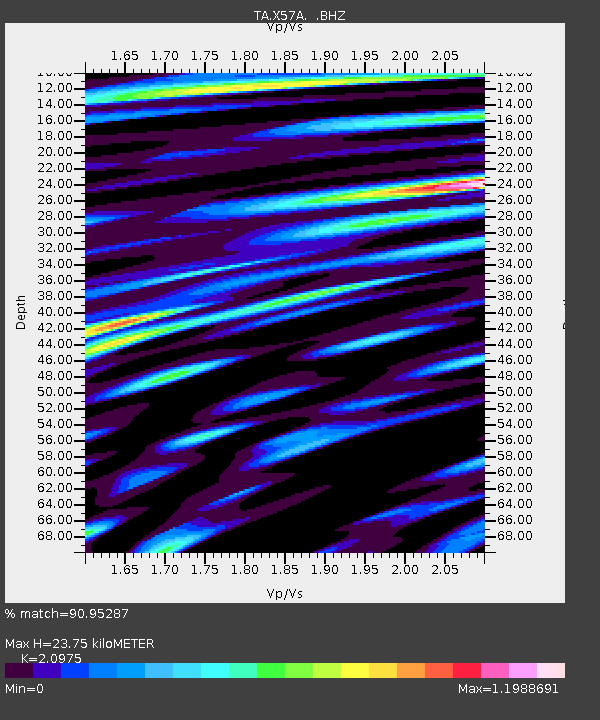
| Estimated Moho Depth: |
23.75 km |
| Estimated Crust Vp/Vs: |
2.10 |
| Assumed Crust Vp: |
6.419 km/s |
| Estimated Crust Vs: |
3.06 km/s |
| Estimated Crust Poisson's Ratio: |
0.35 |
|
| Radial Match: |
90.95287 % |
| Radial Bump: |
400 |
| Transverse Match: |
67.92409 % |
| Transverse Bump: |
400 |
| SOD ConfigId: |
626651 |
| Insert Time: |
2014-04-21 03:19:58.571 +0000 |
| GWidth: |
2.5 |
| Max Bumps: |
400 |
| Tol: |
0.001 |
|
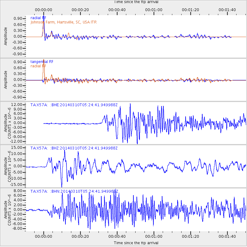
Signal To Noise
| Channel | StoN | STA | LTA |
| TA:X57A: :BHZ:20140310T05:24:41.949988Z | 22.976727 | 3.5900152E-6 | 1.5624573E-7 |
| TA:X57A: :BHN:20140310T05:24:41.949988Z | 8.745638 | 1.0861456E-6 | 1.2419285E-7 |
| TA:X57A: :BHE:20140310T05:24:41.949988Z | 18.471764 | 2.4315984E-6 | 1.3163867E-7 |
| Arrivals |
| Ps | 4.3 SECOND |
| PpPs | 11 SECOND |
| PsPs/PpSs | 15 SECOND |


