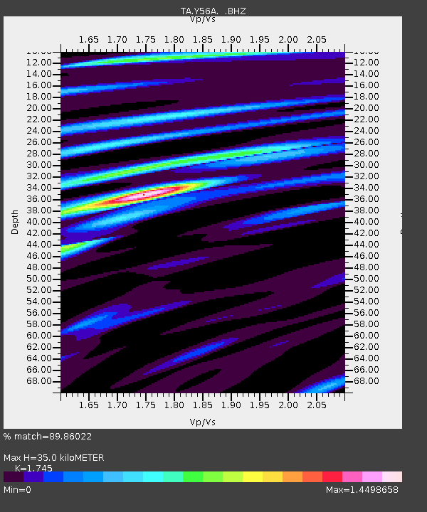
Y56A Pelion, SC, USA - Earthquake Result Viewer
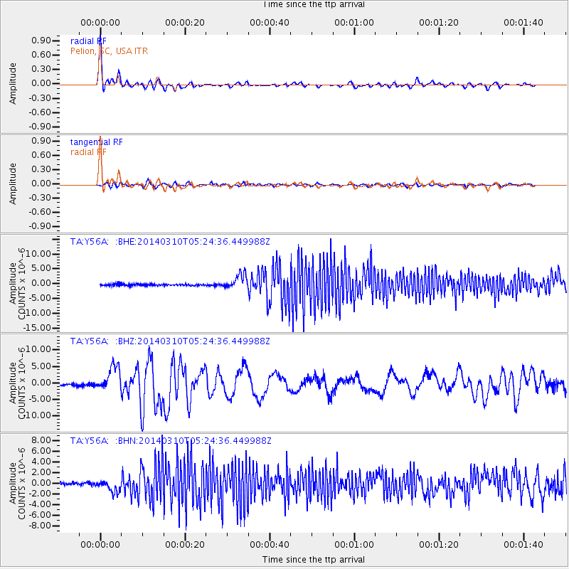
Earthquake location: Off Coast Of Northern California
Earthquake latitude/longitude: 40.8/-125.1
Earthquake time(UTC): 2014/03/10 (069) 05:18:13 GMT
Earthquake Depth: 17 km
Earthquake Magnitude: 6.8 MW, 6.8 MWR, 6.9 MWW, 6.9 MWB, 7.0 MI, 7.0 MWC
Earthquake Catalog/Contributor: NEIC PDE/NEIC COMCAT
Network: TA USArray Transportable Network (new EarthScope stations)
Station: Y56A Pelion, SC, USA
Lat/Lon: 33.79 N/81.30 W
Elevation: 154 m
Distance: 35.3 deg
Az: 87.139 deg
Baz: 294.485 deg
Ray Param: 0.077296115
Estimated Moho Depth: 35.0 km
Estimated Crust Vp/Vs: 1.75
Assumed Crust Vp: 6.565 km/s
Estimated Crust Vs: 3.762 km/s
Estimated Crust Poisson's Ratio: 0.26
Radial Match: 89.86022 %
Radial Bump: 400
Transverse Match: 82.502205 %
Transverse Bump: 400
SOD ConfigId: 626651
Insert Time: 2014-04-21 03:20:12.784 +0000
GWidth: 2.5
Max Bumps: 400
Tol: 0.001

Signal To Noise

ChannelStoNSTALTA
TA:Y56A: :BHZ:20140310T05:24:36.449988Z7.2455383.8391117E-65.2985877E-7
TA:Y56A: :BHN:20140310T05:24:36.449988Z2.98058271.1498383E-63.8577636E-7
TA:Y56A: :BHE:20140310T05:24:36.449988Z8.7289362.460865E-62.819204E-7
Arrivals
Ps4.3 SECOND
PpPs13 SECOND
PsPs/PpSs18 SECOND