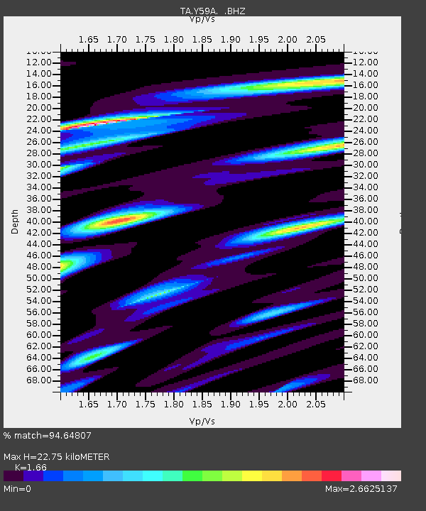
Y59A Loris, SC, USA - Earthquake Result Viewer

Earthquake location: Off Coast Of Northern California
Earthquake latitude/longitude: 40.8/-125.1
Earthquake time(UTC): 2014/03/10 (069) 05:18:13 GMT
Earthquake Depth: 17 km
Earthquake Magnitude: 6.8 MW, 6.8 MWR, 6.9 MWW, 6.9 MWB, 7.0 MI, 7.0 MWC
Earthquake Catalog/Contributor: NEIC PDE/NEIC COMCAT
Network: TA USArray Transportable Network (new EarthScope stations)
Station: Y59A Loris, SC, USA
Lat/Lon: 33.99 N/78.87 W
Elevation: 2.0 m
Distance: 37.0 deg
Az: 85.416 deg
Baz: 294.442 deg
Ray Param: 0.076342605
Estimated Moho Depth: 22.75 km
Estimated Crust Vp/Vs: 1.66
Assumed Crust Vp: 6.24 km/s
Estimated Crust Vs: 3.759 km/s
Estimated Crust Poisson's Ratio: 0.22
Radial Match: 94.64807 %
Radial Bump: 400
Transverse Match: 89.49239 %
Transverse Bump: 400
SOD ConfigId: 626651
Insert Time: 2014-04-21 03:20:21.537 +0000
GWidth: 2.5
Max Bumps: 400
Tol: 0.001

Signal To Noise

ChannelStoNSTALTA
TA:Y59A: :BHZ:20140310T05:24:51.449988Z17.7013113.729342E-62.1068169E-7
TA:Y59A: :BHN:20140310T05:24:51.449988Z2.17965341.0554737E-64.8423925E-7
TA:Y59A: :BHE:20140310T05:24:51.449988Z4.67283632.5214085E-65.395885E-7
Arrivals
Ps2.6 SECOND
PpPs9.0 SECOND
PsPs/PpSs12 SECOND