ACSO Alum Creek State Park, Ohio, USA - Earthquake Result Viewer
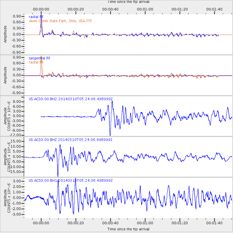
Earthquake location: Off Coast Of Northern California
Earthquake latitude/longitude: 40.8/-125.1
Earthquake time(UTC): 2014/03/10 (069) 05:18:13 GMT
Earthquake Depth: 17 km
Earthquake Magnitude: 6.8 MW, 6.8 MWR, 6.9 MWW, 6.9 MWB, 7.0 MI, 7.0 MWC
Earthquake Catalog/Contributor: NEIC PDE/NEIC COMCAT
Network: US United States National Seismic Network
Station: ACSO Alum Creek State Park, Ohio, USA
Lat/Lon: 40.23 N/82.98 W
Elevation: 288 m
Distance: 31.8 deg
Az: 77.007 deg
Baz: 285.022 deg
Ray Param: 0.07890095
Estimated Moho Depth: 49.75 km
Estimated Crust Vp/Vs: 1.81
Assumed Crust Vp: 6.498 km/s
Estimated Crust Vs: 3.6 km/s
Estimated Crust Poisson's Ratio: 0.28
Radial Match: 97.259865 %
Radial Bump: 262
Transverse Match: 87.586845 %
Transverse Bump: 400
SOD ConfigId: 626651
Insert Time: 2014-04-21 03:20:51.957 +0000
GWidth: 2.5
Max Bumps: 400
Tol: 0.001

Signal To Noise

ChannelStoNSTALTA
US:ACSO:00:BHZ:20140310T05:24:06.498999Z25.1260033.2756259E-61.3036797E-7
US:ACSO:00:BH1:20140310T05:24:06.498999Z4.01147945.8939366E-71.4692675E-7
US:ACSO:00:BH2:20140310T05:24:06.498999Z23.2527752.2798934E-69.8048226E-8
Arrivals
Ps6.7 SECOND
PpPs20 SECOND
PsPs/PpSs27 SECOND