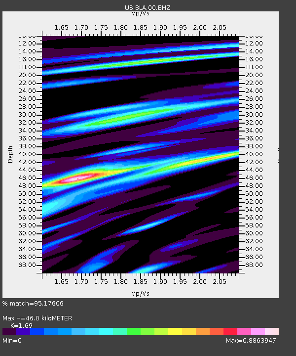
BLA Blacksburg, Virginia, USA - Earthquake Result Viewer
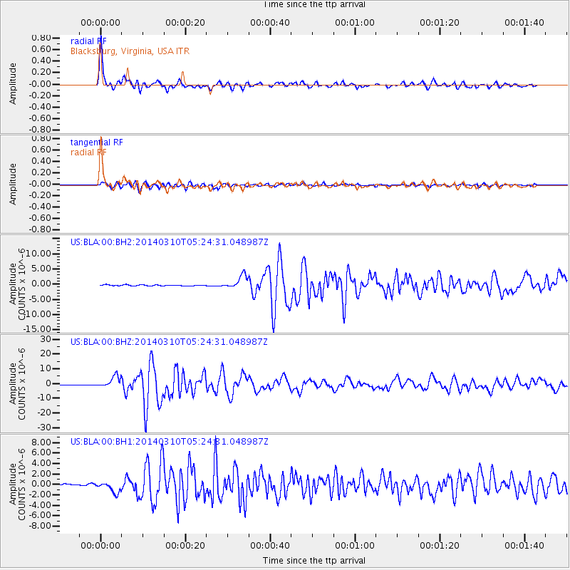
Earthquake location: Off Coast Of Northern California
Earthquake latitude/longitude: 40.8/-125.1
Earthquake time(UTC): 2014/03/10 (069) 05:18:13 GMT
Earthquake Depth: 17 km
Earthquake Magnitude: 6.8 MW, 6.8 MWR, 6.9 MWW, 6.9 MWB, 7.0 MI, 7.0 MWC
Earthquake Catalog/Contributor: NEIC PDE/NEIC COMCAT
Network: US United States National Seismic Network
Station: BLA Blacksburg, Virginia, USA
Lat/Lon: 37.21 N/80.42 W
Elevation: 634 m
Distance: 34.6 deg
Az: 81.151 deg
Baz: 290.086 deg
Ray Param: 0.07762032
Estimated Moho Depth: 46.0 km
Estimated Crust Vp/Vs: 1.69
Assumed Crust Vp: 6.159 km/s
Estimated Crust Vs: 3.644 km/s
Estimated Crust Poisson's Ratio: 0.23
Radial Match: 95.17606 %
Radial Bump: 343
Transverse Match: 88.34621 %
Transverse Bump: 400
SOD ConfigId: 626651
Insert Time: 2014-04-21 03:20:56.953 +0000
GWidth: 2.5
Max Bumps: 400
Tol: 0.001

Signal To Noise

ChannelStoNSTALTA
US:BLA:00:BHZ:20140310T05:24:31.048987Z19.3745043.9348006E-62.0309167E-7
US:BLA:00:BH1:20140310T05:24:31.048987Z5.51153331.0634651E-61.9295267E-7
US:BLA:00:BH2:20140310T05:24:31.048987Z14.6344712.258615E-61.5433527E-7
Arrivals
Ps5.5 SECOND
PpPs19 SECOND
PsPs/PpSs24 SECOND