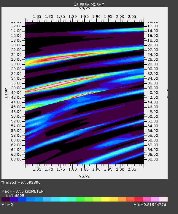
ERPA Erie, Pennsylvania, USA - Earthquake Result Viewer
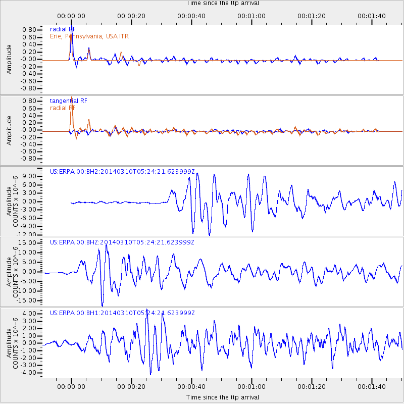
Earthquake location: Off Coast Of Northern California
Earthquake latitude/longitude: 40.8/-125.1
Earthquake time(UTC): 2014/03/10 (069) 05:18:13 GMT
Earthquake Depth: 17 km
Earthquake Magnitude: 6.8 MW, 6.8 MWR, 6.9 MWW, 6.9 MWB, 7.0 MI, 7.0 MWC
Earthquake Catalog/Contributor: NEIC PDE/NEIC COMCAT
Network: US United States National Seismic Network
Station: ERPA Erie, Pennsylvania, USA
Lat/Lon: 42.12 N/79.99 W
Elevation: 306 m
Distance: 33.6 deg
Az: 72.602 deg
Baz: 283.278 deg
Ray Param: 0.07814073
Estimated Moho Depth: 37.5 km
Estimated Crust Vp/Vs: 1.68
Assumed Crust Vp: 6.419 km/s
Estimated Crust Vs: 3.815 km/s
Estimated Crust Poisson's Ratio: 0.23
Radial Match: 97.092896 %
Radial Bump: 233
Transverse Match: 83.78719 %
Transverse Bump: 400
SOD ConfigId: 626651
Insert Time: 2014-04-21 03:21:08.362 +0000
GWidth: 2.5
Max Bumps: 400
Tol: 0.001

Signal To Noise

ChannelStoNSTALTA
US:ERPA:00:BHZ:20140310T05:24:21.623999Z24.2188283.188199E-61.3164133E-7
US:ERPA:00:BH1:20140310T05:24:21.623999Z2.1024554.8397294E-72.3019419E-7
US:ERPA:00:BH2:20140310T05:24:21.623999Z11.5913162.1401315E-61.846323E-7
Arrivals
Ps4.3 SECOND
PpPs14 SECOND
PsPs/PpSs19 SECOND