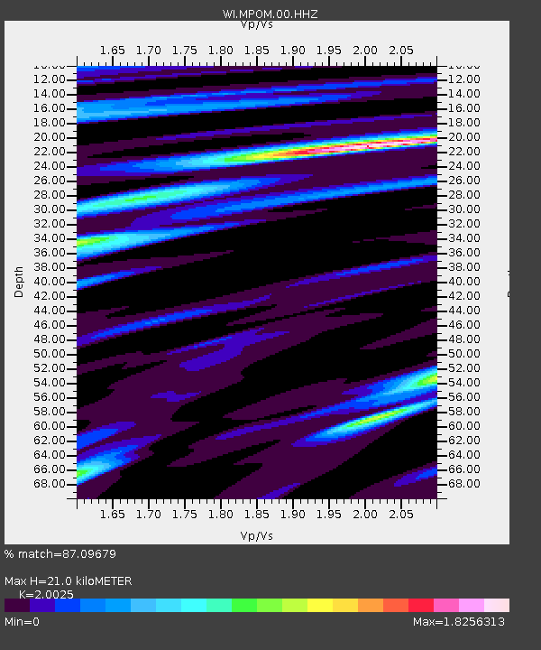
MPOM Morne Pois, Sainte-Anne, Martinique - Earthquake Result Viewer

Earthquake location: Off Coast Of Northern California
Earthquake latitude/longitude: 40.8/-125.1
Earthquake time(UTC): 2014/03/10 (069) 05:18:13 GMT
Earthquake Depth: 17 km
Earthquake Magnitude: 6.8 MW, 6.8 MWR, 6.9 MWW, 6.9 MWB, 7.0 MI, 7.0 MWC
Earthquake Catalog/Contributor: NEIC PDE/NEIC COMCAT
Network: WI West Indies IPGP Network
Station: MPOM Morne Pois, Sainte-Anne, Martinique
Lat/Lon: 14.45 N/60.86 W
Elevation: 50 m
Distance: 61.3 deg
Az: 95.611 deg
Baz: 308.782 deg
Ray Param: 0.06096192
Estimated Moho Depth: 21.0 km
Estimated Crust Vp/Vs: 2.00
Assumed Crust Vp: 5.88 km/s
Estimated Crust Vs: 2.937 km/s
Estimated Crust Poisson's Ratio: 0.33
Radial Match: 87.09679 %
Radial Bump: 400
Transverse Match: 85.793816 %
Transverse Bump: 400
SOD ConfigId: 626651
Insert Time: 2014-04-21 03:21:45.224 +0000
GWidth: 2.5
Max Bumps: 400
Tol: 0.001

Signal To Noise

ChannelStoNSTALTA
WI:MPOM:00:HHZ:20140310T05:27:56.619971Z3.91046051.8582192E-64.751919E-7
WI:MPOM:00:HHN:20140310T05:27:56.619971Z1.74023436.9093403E-73.9703508E-7
WI:MPOM:00:HHE:20140310T05:27:56.619971Z2.01199466.62698E-73.2937368E-7
Arrivals
Ps3.7 SECOND
PpPs10 SECOND
PsPs/PpSs14 SECOND