You are here: Home > Network List > CI - Caltech Regional Seismic Network Stations List
> Station CIA CIA, Avalon Catalina Island, CA, USA > Earthquake Result Viewer
CIA CIA, Avalon Catalina Island, CA, USA - Earthquake Result Viewer
| Earthquake location: |
Off East Coast Of Honshu, Japan |
| Earthquake latitude/longitude: |
38.1/144.9 |
| Earthquake time(UTC): |
2005/11/14 (318) 21:38:51 GMT |
| Earthquake Depth: |
11 km |
| Earthquake Magnitude: |
6.7 MB, 6.8 MS, 7.0 MW, 6.9 MW |
| Earthquake Catalog/Contributor: |
WHDF/NEIC |
|
| Network: |
CI Caltech Regional Seismic Network |
| Station: |
CIA CIA, Avalon Catalina Island, CA, USA |
| Lat/Lon: |
33.40 N/118.41 W |
| Elevation: |
467 m |
|
| Distance: |
74.9 deg |
| Az: |
59.36 deg |
| Baz: |
305.77 deg |
| Ray Param: |
0.05199521 |
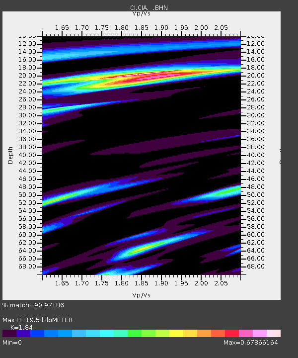
| Estimated Moho Depth: |
19.5 km |
| Estimated Crust Vp/Vs: |
1.84 |
| Assumed Crust Vp: |
6.048 km/s |
| Estimated Crust Vs: |
3.287 km/s |
| Estimated Crust Poisson's Ratio: |
0.29 |
|
| Radial Match: |
90.97186 % |
| Radial Bump: |
400 |
| Transverse Match: |
88.912094 % |
| Transverse Bump: |
400 |
| SOD ConfigId: |
2448 |
| Insert Time: |
2010-02-25 20:58:06.707 +0000 |
| GWidth: |
2.5 |
| Max Bumps: |
400 |
| Tol: |
0.001 |
|

Signal To Noise
| Channel | StoN | STA | LTA |
| CI:CIA: :BHN:20051114T21:50:01.058Z | 2.086337 | 8.2029504E-7 | 3.9317476E-7 |
| CI:CIA: :BHE:20051114T21:50:01.058Z | 2.83629 | 1.1886375E-6 | 4.1908183E-7 |
| CI:CIA: :BHZ:20051114T21:50:01.058Z | 5.5411925 | 3.4074285E-6 | 6.1492693E-7 |
| Arrivals |
| Ps | 2.8 SECOND |
| PpPs | 8.9 SECOND |
| PsPs/PpSs | 12 SECOND |


