You are here: Home > Network List > TA - USArray Transportable Network (new EarthScope stations) Stations List
> Station J04D Umpqua National Forest, Toketee, OR, USA > Earthquake Result Viewer
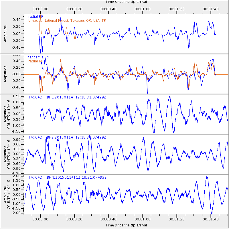
J04D Umpqua National Forest, Toketee, OR, USA - Earthquake Result Viewer
*The percent match for this event was below the threshold and hence no stack was calculated.
| Earthquake location: |
Sakhalin, Russia |
| Earthquake latitude/longitude: |
48.9/142.1 |
| Earthquake time(UTC): |
2015/01/14 (014) 12:09:35 GMT |
| Earthquake Depth: |
585 km |
| Earthquake Magnitude: |
5.3 MW, 5.0 mb |
| Earthquake Catalog/Contributor: |
ISC/ISC |
|
| Network: |
TA USArray Transportable Network (new EarthScope stations) |
| Station: |
J04D Umpqua National Forest, Toketee, OR, USA |
| Lat/Lon: |
43.24 N/122.11 W |
| Elevation: |
1948 m |
|
| Distance: |
62.4 deg |
| Az: |
55.158 deg |
| Baz: |
312.118 deg |
| Ray Param: |
$rayparam |
*The percent match for this event was below the threshold and hence was not used in the summary stack. |
|
| Radial Match: |
57.230785 % |
| Radial Bump: |
400 |
| Transverse Match: |
61.00243 % |
| Transverse Bump: |
400 |
| SOD ConfigId: |
3390531 |
| Insert Time: |
2019-04-16 01:28:46.683 +0000 |
| GWidth: |
2.5 |
| Max Bumps: |
400 |
| Tol: |
0.001 |
|
Signal To Noise
| Channel | StoN | STA | LTA |
| TA:J04D: :BHZ:20150114T12:18:31.07499Z | 1.1829787 | 4.985351E-7 | 4.2142355E-7 |
| TA:J04D: :BHN:20150114T12:18:31.07499Z | 1.7981263 | 1.0848948E-6 | 6.033474E-7 |
| TA:J04D: :BHE:20150114T12:18:31.07499Z | 0.8516993 | 3.157381E-7 | 3.707155E-7 |
| Arrivals |
| Ps | |
| PpPs | |
| PsPs/PpSs | |


