You are here: Home > Network List > TA - USArray Transportable Network (new EarthScope stations) Stations List
> Station J04D Umpqua National Forest, Toketee, OR, USA > Earthquake Result Viewer
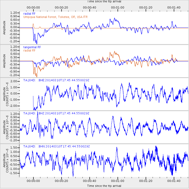
J04D Umpqua National Forest, Toketee, OR, USA - Earthquake Result Viewer
*The percent match for this event was below the threshold and hence no stack was calculated.
| Earthquake location: |
Eastern New Guinea Reg., P.N.G. |
| Earthquake latitude/longitude: |
-5.5/148.0 |
| Earthquake time(UTC): |
2014/03/10 (069) 17:33:30 GMT |
| Earthquake Depth: |
269 km |
| Earthquake Magnitude: |
5.9 MWB, 5.9 MWW, 6.0 MWC |
| Earthquake Catalog/Contributor: |
NEIC PDE/NEIC COMCAT |
|
| Network: |
TA USArray Transportable Network (new EarthScope stations) |
| Station: |
J04D Umpqua National Forest, Toketee, OR, USA |
| Lat/Lon: |
43.24 N/122.11 W |
| Elevation: |
1948 m |
|
| Distance: |
93.7 deg |
| Az: |
47.077 deg |
| Baz: |
265.959 deg |
| Ray Param: |
$rayparam |
*The percent match for this event was below the threshold and hence was not used in the summary stack. |
|
| Radial Match: |
55.389782 % |
| Radial Bump: |
400 |
| Transverse Match: |
42.407677 % |
| Transverse Bump: |
400 |
| SOD ConfigId: |
626651 |
| Insert Time: |
2014-04-21 03:34:38.010 +0000 |
| GWidth: |
2.5 |
| Max Bumps: |
400 |
| Tol: |
0.001 |
|
Signal To Noise
| Channel | StoN | STA | LTA |
| TA:J04D: :BHZ:20140310T17:45:44.550029Z | 2.4804857 | 5.097321E-7 | 2.0549689E-7 |
| TA:J04D: :BHN:20140310T17:45:44.550029Z | 1.0693413 | 6.8789024E-7 | 6.432841E-7 |
| TA:J04D: :BHE:20140310T17:45:44.550029Z | 0.75812453 | 8.3645256E-7 | 1.1033181E-6 |
| Arrivals |
| Ps | |
| PpPs | |
| PsPs/PpSs | |


