You are here: Home > Network List > US - United States National Seismic Network Stations List
> Station HAWA Hanford, Washington, USA > Earthquake Result Viewer
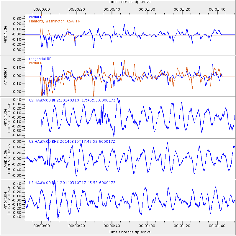
HAWA Hanford, Washington, USA - Earthquake Result Viewer
*The percent match for this event was below the threshold and hence no stack was calculated.
| Earthquake location: |
Eastern New Guinea Reg., P.N.G. |
| Earthquake latitude/longitude: |
-5.5/148.0 |
| Earthquake time(UTC): |
2014/03/10 (069) 17:33:30 GMT |
| Earthquake Depth: |
269 km |
| Earthquake Magnitude: |
5.9 MWB, 5.9 MWW, 6.0 MWC |
| Earthquake Catalog/Contributor: |
NEIC PDE/NEIC COMCAT |
|
| Network: |
US United States National Seismic Network |
| Station: |
HAWA Hanford, Washington, USA |
| Lat/Lon: |
46.39 N/119.53 W |
| Elevation: |
364 m |
|
| Distance: |
95.7 deg |
| Az: |
44.017 deg |
| Baz: |
268.019 deg |
| Ray Param: |
$rayparam |
*The percent match for this event was below the threshold and hence was not used in the summary stack. |
|
| Radial Match: |
50.337643 % |
| Radial Bump: |
400 |
| Transverse Match: |
42.02828 % |
| Transverse Bump: |
400 |
| SOD ConfigId: |
626651 |
| Insert Time: |
2014-04-21 03:35:31.766 +0000 |
| GWidth: |
2.5 |
| Max Bumps: |
400 |
| Tol: |
0.001 |
|
Signal To Noise
| Channel | StoN | STA | LTA |
| US:HAWA:00:BHZ:20140310T17:45:53.600017Z | 2.1191652 | 2.248221E-7 | 1.06089935E-7 |
| US:HAWA:00:BH1:20140310T17:45:53.600017Z | 2.0658574 | 2.6122882E-7 | 1.2645056E-7 |
| US:HAWA:00:BH2:20140310T17:45:53.600017Z | 0.7742051 | 1.335866E-7 | 1.7254679E-7 |
| Arrivals |
| Ps | |
| PpPs | |
| PsPs/PpSs | |


