You are here: Home > Network List > UW - Pacific Northwest Regional Seismic Network Stations List
> Station HOOD Mt Hood Meadows, OR CREST BB SMO > Earthquake Result Viewer
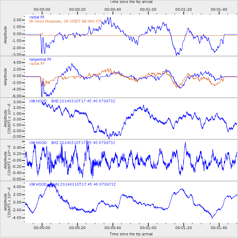
HOOD Mt Hood Meadows, OR CREST BB SMO - Earthquake Result Viewer
*The percent match for this event was below the threshold and hence no stack was calculated.
| Earthquake location: |
Eastern New Guinea Reg., P.N.G. |
| Earthquake latitude/longitude: |
-5.5/148.0 |
| Earthquake time(UTC): |
2014/03/10 (069) 17:33:30 GMT |
| Earthquake Depth: |
269 km |
| Earthquake Magnitude: |
5.9 MWB, 5.9 MWW, 6.0 MWC |
| Earthquake Catalog/Contributor: |
NEIC PDE/NEIC COMCAT |
|
| Network: |
UW Pacific Northwest Regional Seismic Network |
| Station: |
HOOD Mt Hood Meadows, OR CREST BB SMO |
| Lat/Lon: |
45.32 N/121.65 W |
| Elevation: |
1520 m |
|
| Distance: |
94.1 deg |
| Az: |
45.018 deg |
| Baz: |
266.416 deg |
| Ray Param: |
$rayparam |
*The percent match for this event was below the threshold and hence was not used in the summary stack. |
|
| Radial Match: |
46.824257 % |
| Radial Bump: |
400 |
| Transverse Match: |
67.293236 % |
| Transverse Bump: |
400 |
| SOD ConfigId: |
626651 |
| Insert Time: |
2014-04-21 03:35:49.129 +0000 |
| GWidth: |
2.5 |
| Max Bumps: |
400 |
| Tol: |
0.001 |
|
Signal To Noise
| Channel | StoN | STA | LTA |
| UW:HOOD: :BHZ:20140310T17:45:46.679973Z | 1.4301132 | 2.8615702E-7 | 2.0009396E-7 |
| UW:HOOD: :BHN:20140310T17:45:46.679973Z | 4.1921153 | 4.848689E-6 | 1.1566211E-6 |
| UW:HOOD: :BHE:20140310T17:45:46.679973Z | 5.479223 | 3.5642572E-6 | 6.5050415E-7 |
| Arrivals |
| Ps | |
| PpPs | |
| PsPs/PpSs | |


